You are here: Home > Network List > TA - USArray Transportable Network (new EarthScope stations) Stations List
> Station 242A Grayson, LA, USA > Earthquake Result Viewer
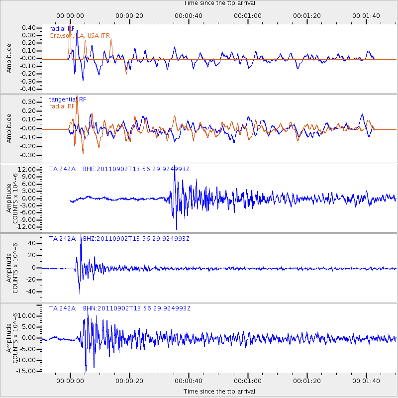
242A Grayson, LA, USA - Earthquake Result Viewer
*The percent match for this event was below the threshold and hence no stack was calculated.
| Earthquake location: |
Santiago Del Estero Prov., Arg. |
| Earthquake latitude/longitude: |
-28.4/-63.0 |
| Earthquake time(UTC): |
2011/09/02 (245) 13:47:09 GMT |
| Earthquake Depth: |
579 km |
| Earthquake Magnitude: |
6.4 MB, 6.7 MW, 6.7 MW |
| Earthquake Catalog/Contributor: |
WHDF/NEIC |
|
| Network: |
TA USArray Transportable Network (new EarthScope stations) |
| Station: |
242A Grayson, LA, USA |
| Lat/Lon: |
32.06 N/92.15 W |
| Elevation: |
57 m |
|
| Distance: |
66.2 deg |
| Az: |
333.151 deg |
| Baz: |
152.055 deg |
| Ray Param: |
$rayparam |
*The percent match for this event was below the threshold and hence was not used in the summary stack. |
|
| Radial Match: |
87.77257 % |
| Radial Bump: |
400 |
| Transverse Match: |
69.15446 % |
| Transverse Bump: |
400 |
| SOD ConfigId: |
414626 |
| Insert Time: |
2012-01-18 09:15:48.377 +0000 |
| GWidth: |
2.5 |
| Max Bumps: |
400 |
| Tol: |
0.001 |
|
Signal To Noise
| Channel | StoN | STA | LTA |
| TA:242A: :BHZ:20110902T13:56:29.924993Z | 68.23308 | 1.5568372E-5 | 2.2816458E-7 |
| TA:242A: :BHN:20110902T13:56:29.924993Z | 4.5121565 | 2.5043275E-6 | 5.550179E-7 |
| TA:242A: :BHE:20110902T13:56:29.924993Z | 4.712852 | 2.1320473E-6 | 4.5239003E-7 |
| Arrivals |
| Ps | |
| PpPs | |
| PsPs/PpSs | |


