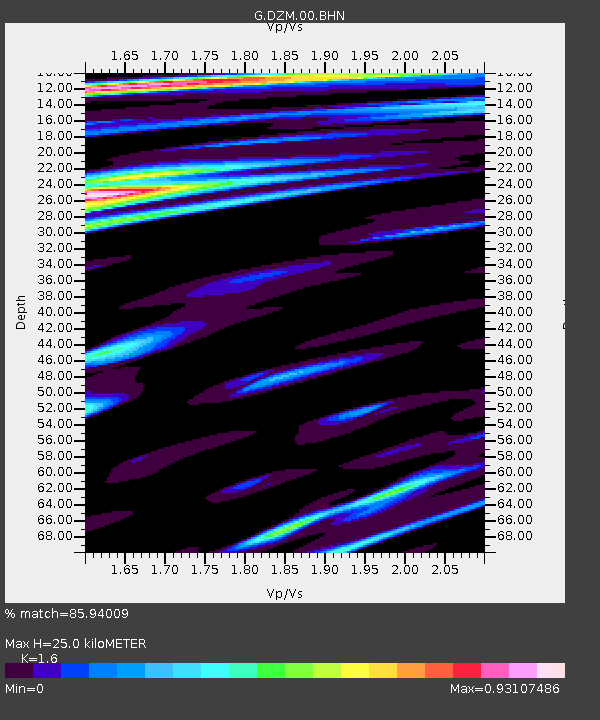
DZM Dzumac, New Caledonia - Earthquake Result Viewer
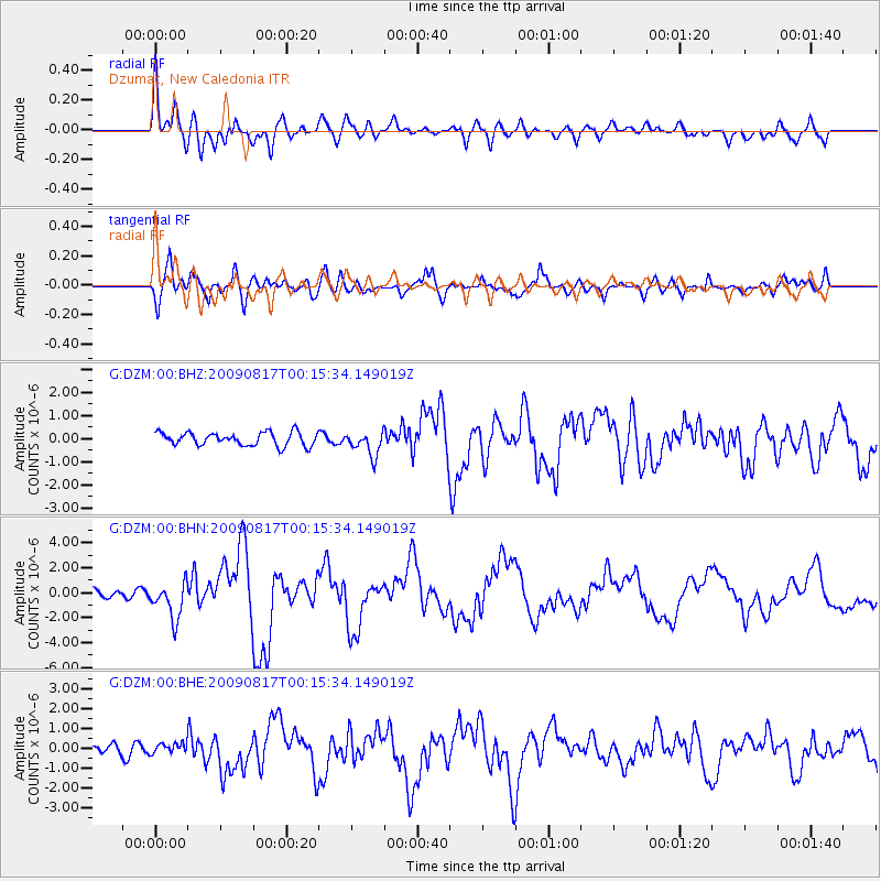
Earthquake location: Southwestern Ryukyu Isl., Japan
Earthquake latitude/longitude: 23.5/123.5
Earthquake time(UTC): 2009/08/17 (229) 00:05:49 GMT
Earthquake Depth: 20 km
Earthquake Magnitude: 6.2 MB, 6.6 MS, 6.7 MW, 6.6 MW
Earthquake Catalog/Contributor: WHDF/NEIC
Network: G GEOSCOPE
Station: DZM Dzumac, New Caledonia
Lat/Lon: 22.07 S/166.44 E
Elevation: 878 m
Distance: 61.6 deg
Az: 134.091 deg
Baz: 314.697 deg
Ray Param: 0.060731653
Estimated Moho Depth: 25.0 km
Estimated Crust Vp/Vs: 1.60
Assumed Crust Vp: 5.14 km/s
Estimated Crust Vs: 3.212 km/s
Estimated Crust Poisson's Ratio: 0.18
Radial Match: 85.94009 %
Radial Bump: 400
Transverse Match: 84.02384 %
Transverse Bump: 400
SOD ConfigId: 2622
Insert Time: 2010-02-26 22:17:57.330 +0000
GWidth: 2.5
Max Bumps: 400
Tol: 0.001

Signal To Noise

ChannelStoNSTALTA
G:DZM:00:BHN:20090817T00:15:34.149019Z3.17736891.4693766E-64.6245074E-7
G:DZM:00:BHE:20090817T00:15:34.149019Z1.13283692.6828852E-72.368289E-7
G:DZM:00:BHZ:20090817T00:15:34.149019Z1.81532915.2246975E-72.8780994E-7
Arrivals
Ps3.0 SECOND
PpPs12 SECOND
PsPs/PpSs15 SECOND