You are here: Home > Network List > TA - USArray Transportable Network (new EarthScope stations) Stations List
> Station X45A UM Field Station, Abbeville, MS, USA > Earthquake Result Viewer
X45A UM Field Station, Abbeville, MS, USA - Earthquake Result Viewer
| Earthquake location: |
Santiago Del Estero Prov., Arg. |
| Earthquake latitude/longitude: |
-28.4/-63.0 |
| Earthquake time(UTC): |
2011/09/02 (245) 13:47:09 GMT |
| Earthquake Depth: |
579 km |
| Earthquake Magnitude: |
6.4 MB, 6.7 MW, 6.7 MW |
| Earthquake Catalog/Contributor: |
WHDF/NEIC |
|
| Network: |
TA USArray Transportable Network (new EarthScope stations) |
| Station: |
X45A UM Field Station, Abbeville, MS, USA |
| Lat/Lon: |
34.42 N/89.39 W |
| Elevation: |
142 m |
|
| Distance: |
67.3 deg |
| Az: |
336.548 deg |
| Baz: |
154.903 deg |
| Ray Param: |
0.054985724 |
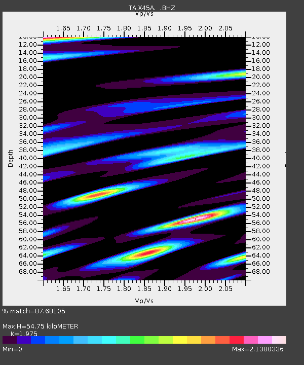
| Estimated Moho Depth: |
54.75 km |
| Estimated Crust Vp/Vs: |
1.98 |
| Assumed Crust Vp: |
6.38 km/s |
| Estimated Crust Vs: |
3.231 km/s |
| Estimated Crust Poisson's Ratio: |
0.33 |
|
| Radial Match: |
87.68105 % |
| Radial Bump: |
400 |
| Transverse Match: |
80.55611 % |
| Transverse Bump: |
400 |
| SOD ConfigId: |
414626 |
| Insert Time: |
2012-01-18 09:21:51.903 +0000 |
| GWidth: |
2.5 |
| Max Bumps: |
400 |
| Tol: |
0.001 |
|

Signal To Noise
| Channel | StoN | STA | LTA |
| TA:X45A: :BHZ:20110902T13:56:36.525029Z | 67.3414 | 1.0647085E-5 | 1.5810609E-7 |
| TA:X45A: :BHN:20110902T13:56:36.525029Z | 14.4665785 | 2.9409257E-6 | 2.0329104E-7 |
| TA:X45A: :BHE:20110902T13:56:36.525029Z | 8.839099 | 1.6415013E-6 | 1.8570911E-7 |
| Arrivals |
| Ps | 8.6 SECOND |
| PpPs | 25 SECOND |
| PsPs/PpSs | 33 SECOND |


