You are here: Home > Network List > TA - USArray Transportable Network (new EarthScope stations) Stations List
> Station Q43A New Douglas, IL, USA > Earthquake Result Viewer
Q43A New Douglas, IL, USA - Earthquake Result Viewer
| Earthquake location: |
Santiago Del Estero Prov., Arg. |
| Earthquake latitude/longitude: |
-28.4/-63.0 |
| Earthquake time(UTC): |
2011/09/02 (245) 13:47:09 GMT |
| Earthquake Depth: |
579 km |
| Earthquake Magnitude: |
6.4 MB, 6.7 MW, 6.7 MW |
| Earthquake Catalog/Contributor: |
WHDF/NEIC |
|
| Network: |
TA USArray Transportable Network (new EarthScope stations) |
| Station: |
Q43A New Douglas, IL, USA |
| Lat/Lon: |
38.94 N/89.70 W |
| Elevation: |
202 m |
|
| Distance: |
71.5 deg |
| Az: |
338.335 deg |
| Baz: |
155.351 deg |
| Ray Param: |
0.052342232 |
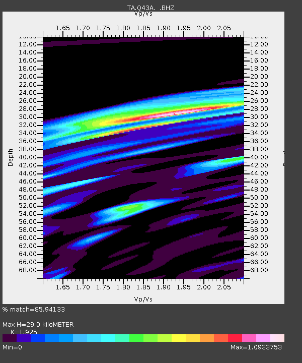
| Estimated Moho Depth: |
29.0 km |
| Estimated Crust Vp/Vs: |
1.92 |
| Assumed Crust Vp: |
6.444 km/s |
| Estimated Crust Vs: |
3.347 km/s |
| Estimated Crust Poisson's Ratio: |
0.32 |
|
| Radial Match: |
85.94133 % |
| Radial Bump: |
400 |
| Transverse Match: |
79.6495 % |
| Transverse Bump: |
400 |
| SOD ConfigId: |
414626 |
| Insert Time: |
2012-01-18 09:22:32.763 +0000 |
| GWidth: |
2.5 |
| Max Bumps: |
400 |
| Tol: |
0.001 |
|
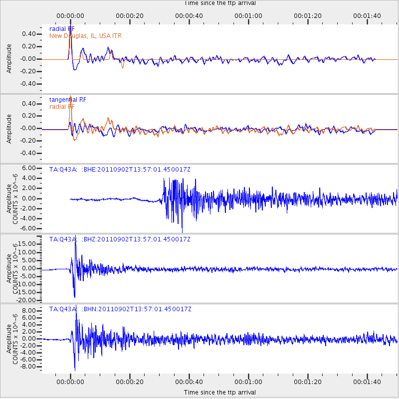
Signal To Noise
| Channel | StoN | STA | LTA |
| TA:Q43A: :BHZ:20110902T13:57:01.450017Z | 27.461906 | 6.515867E-6 | 2.3726928E-7 |
| TA:Q43A: :BHN:20110902T13:57:01.450017Z | 24.16049 | 2.9290338E-6 | 1.2123239E-7 |
| TA:Q43A: :BHE:20110902T13:57:01.450017Z | 14.360439 | 1.7512212E-6 | 1.2194761E-7 |
| Arrivals |
| Ps | 4.3 SECOND |
| PpPs | 13 SECOND |
| PsPs/PpSs | 17 SECOND |


