You are here: Home > Network List > TA - USArray Transportable Network (new EarthScope stations) Stations List
> Station U42A Revenden, AR, USA > Earthquake Result Viewer
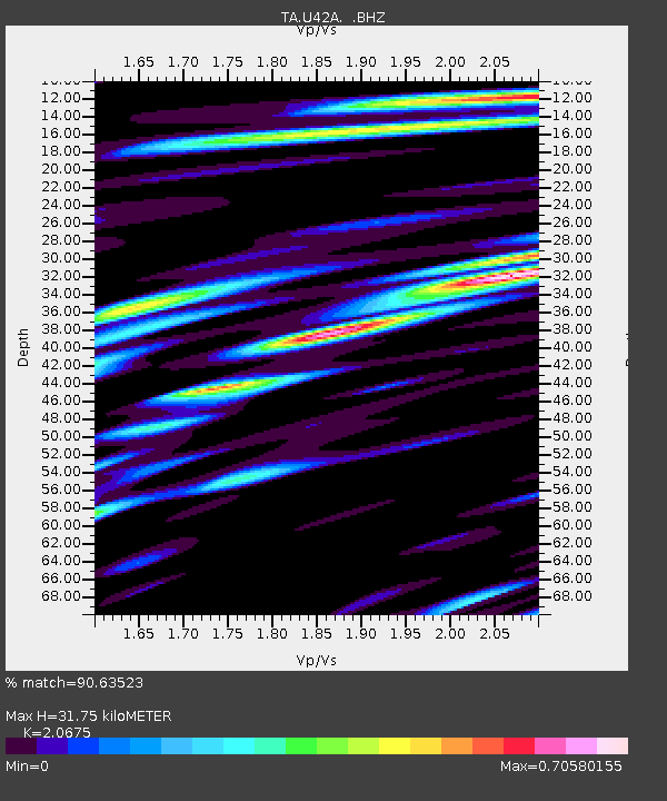
U42A Revenden, AR, USA - Earthquake Result Viewer
| Earthquake location: |
Santiago Del Estero Prov., Arg. |
| Earthquake latitude/longitude: |
-28.4/-63.0 |
| Earthquake time(UTC): |
2011/09/02 (245) 13:47:09 GMT |
| Earthquake Depth: |
579 km |
| Earthquake Magnitude: |
6.4 MB, 6.7 MW, 6.7 MW |
| Earthquake Catalog/Contributor: |
WHDF/NEIC |
|
| Network: |
TA USArray Transportable Network (new EarthScope stations) |
| Station: |
U42A Revenden, AR, USA |
| Lat/Lon: |
36.35 N/91.24 W |
| Elevation: |
119 m |
|
| Distance: |
69.7 deg |
| Az: |
335.985 deg |
| Baz: |
153.633 deg |
| Ray Param: |
0.053485524 |
| Estimated Moho Depth: |
31.75 km |
| Estimated Crust Vp/Vs: |
2.07 |
| Assumed Crust Vp: |
6.53 km/s |
| Estimated Crust Vs: |
3.159 km/s |
| Estimated Crust Poisson's Ratio: |
0.35 |
|
| Radial Match: |
90.63523 % |
| Radial Bump: |
400 |
| Transverse Match: |
88.69588 % |
| Transverse Bump: |
400 |
| SOD ConfigId: |
414626 |
| Insert Time: |
2012-01-18 09:24:23.327 +0000 |
| GWidth: |
2.5 |
| Max Bumps: |
400 |
| Tol: |
0.001 |
|

Signal To Noise
| Channel | StoN | STA | LTA |
| TA:U42A: :BHZ:20110902T13:56:50.84998Z | 30.82891 | 4.8060156E-6 | 1.5589313E-7 |
| TA:U42A: :BHN:20110902T13:56:50.84998Z | 16.252968 | 2.2620554E-6 | 1.39178E-7 |
| TA:U42A: :BHE:20110902T13:56:50.84998Z | 10.672928 | 1.028993E-6 | 9.64115E-8 |
| Arrivals |
| Ps | 5.4 SECOND |
| PpPs | 14 SECOND |
| PsPs/PpSs | 20 SECOND |


