You are here: Home > Network List > TA - USArray Transportable Network (new EarthScope stations) Stations List
> Station U43A Rector, AR, USA > Earthquake Result Viewer
U43A Rector, AR, USA - Earthquake Result Viewer
| Earthquake location: |
Santiago Del Estero Prov., Arg. |
| Earthquake latitude/longitude: |
-28.4/-63.0 |
| Earthquake time(UTC): |
2011/09/02 (245) 13:47:09 GMT |
| Earthquake Depth: |
579 km |
| Earthquake Magnitude: |
6.4 MB, 6.7 MW, 6.7 MW |
| Earthquake Catalog/Contributor: |
WHDF/NEIC |
|
| Network: |
TA USArray Transportable Network (new EarthScope stations) |
| Station: |
U43A Rector, AR, USA |
| Lat/Lon: |
36.37 N/90.41 W |
| Elevation: |
96 m |
|
| Distance: |
69.4 deg |
| Az: |
336.639 deg |
| Baz: |
154.353 deg |
| Ray Param: |
0.053659428 |
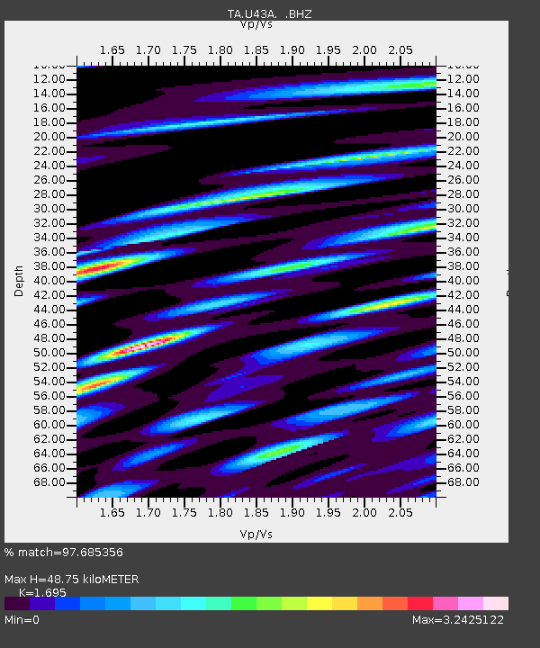
| Estimated Moho Depth: |
48.75 km |
| Estimated Crust Vp/Vs: |
1.70 |
| Assumed Crust Vp: |
6.53 km/s |
| Estimated Crust Vs: |
3.853 km/s |
| Estimated Crust Poisson's Ratio: |
0.23 |
|
| Radial Match: |
97.685356 % |
| Radial Bump: |
354 |
| Transverse Match: |
94.15922 % |
| Transverse Bump: |
400 |
| SOD ConfigId: |
414626 |
| Insert Time: |
2012-01-18 09:25:01.997 +0000 |
| GWidth: |
2.5 |
| Max Bumps: |
400 |
| Tol: |
0.001 |
|

Signal To Noise
| Channel | StoN | STA | LTA |
| TA:U43A: :BHZ:20110902T13:56:49.200017Z | 28.429445 | 1.06768875E-5 | 3.7555736E-7 |
| TA:U43A: :BHN:20110902T13:56:49.200017Z | 34.822117 | 7.2998146E-6 | 2.0963155E-7 |
| TA:U43A: :BHE:20110902T13:56:49.200017Z | 26.533611 | 5.492885E-6 | 2.0701611E-7 |
| Arrivals |
| Ps | 5.4 SECOND |
| PpPs | 19 SECOND |
| PsPs/PpSs | 25 SECOND |


