You are here: Home > Network List > TA - USArray Transportable Network (new EarthScope stations) Stations List
> Station H40A Chili, WI, USA > Earthquake Result Viewer
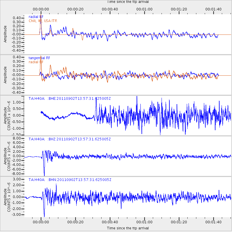
H40A Chili, WI, USA - Earthquake Result Viewer
*The percent match for this event was below the threshold and hence no stack was calculated.
| Earthquake location: |
Santiago Del Estero Prov., Arg. |
| Earthquake latitude/longitude: |
-28.4/-63.0 |
| Earthquake time(UTC): |
2011/09/02 (245) 13:47:09 GMT |
| Earthquake Depth: |
579 km |
| Earthquake Magnitude: |
6.4 MB, 6.7 MW, 6.7 MW |
| Earthquake Catalog/Contributor: |
WHDF/NEIC |
|
| Network: |
TA USArray Transportable Network (new EarthScope stations) |
| Station: |
H40A Chili, WI, USA |
| Lat/Lon: |
44.62 N/90.39 W |
| Elevation: |
372 m |
|
| Distance: |
76.8 deg |
| Az: |
340.303 deg |
| Baz: |
155.429 deg |
| Ray Param: |
$rayparam |
*The percent match for this event was below the threshold and hence was not used in the summary stack. |
|
| Radial Match: |
78.659004 % |
| Radial Bump: |
400 |
| Transverse Match: |
74.2162 % |
| Transverse Bump: |
400 |
| SOD ConfigId: |
414626 |
| Insert Time: |
2012-01-18 09:25:33.988 +0000 |
| GWidth: |
2.5 |
| Max Bumps: |
400 |
| Tol: |
0.001 |
|
Signal To Noise
| Channel | StoN | STA | LTA |
| TA:H40A: :BHZ:20110902T13:57:31.625005Z | 9.389556 | 2.6507944E-6 | 2.8231307E-7 |
| TA:H40A: :BHN:20110902T13:57:31.625005Z | 8.903976 | 1.049995E-6 | 1.1792428E-7 |
| TA:H40A: :BHE:20110902T13:57:31.625005Z | 2.7625413 | 4.343329E-7 | 1.5722223E-7 |
| Arrivals |
| Ps | |
| PpPs | |
| PsPs/PpSs | |


