You are here: Home > Network List > TA - USArray Transportable Network (new EarthScope stations) Stations List
> Station L04D Klamath Falls, OR, USA > Earthquake Result Viewer
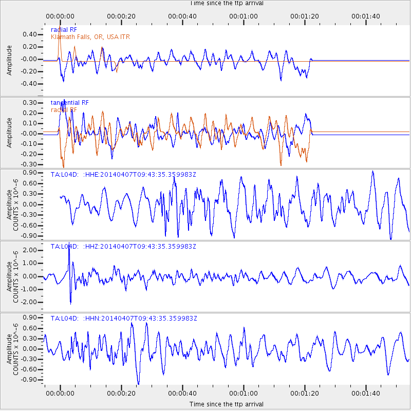
L04D Klamath Falls, OR, USA - Earthquake Result Viewer
*The percent match for this event was below the threshold and hence no stack was calculated.
| Earthquake location: |
Kuril Islands |
| Earthquake latitude/longitude: |
50.4/156.3 |
| Earthquake time(UTC): |
2014/04/07 (097) 09:34:49 GMT |
| Earthquake Depth: |
85 km |
| Earthquake Magnitude: |
5.2 MW |
| Earthquake Catalog/Contributor: |
ISC/ISC |
|
| Network: |
TA USArray Transportable Network (new EarthScope stations) |
| Station: |
L04D Klamath Falls, OR, USA |
| Lat/Lon: |
42.22 N/122.30 W |
| Elevation: |
1437 m |
|
| Distance: |
54.1 deg |
| Az: |
65.005 deg |
| Baz: |
308.7 deg |
| Ray Param: |
$rayparam |
*The percent match for this event was below the threshold and hence was not used in the summary stack. |
|
| Radial Match: |
74.48525 % |
| Radial Bump: |
400 |
| Transverse Match: |
63.39817 % |
| Transverse Bump: |
400 |
| SOD ConfigId: |
3390531 |
| Insert Time: |
2019-04-11 05:02:55.984 +0000 |
| GWidth: |
2.5 |
| Max Bumps: |
400 |
| Tol: |
0.001 |
|
Signal To Noise
| Channel | StoN | STA | LTA |
| TA:L04D: :HHZ:20140407T09:43:35.359983Z | 3.0110772 | 8.7889146E-7 | 2.9188607E-7 |
| TA:L04D: :HHN:20140407T09:43:35.359983Z | 0.7097364 | 2.0332224E-7 | 2.8647574E-7 |
| TA:L04D: :HHE:20140407T09:43:35.359983Z | 1.2169503 | 3.0317122E-7 | 2.4912376E-7 |
| Arrivals |
| Ps | |
| PpPs | |
| PsPs/PpSs | |


