You are here: Home > Network List > UW - Pacific Northwest Regional Seismic Network Stations List
> Station LTY Liberty (broad-band) > Earthquake Result Viewer
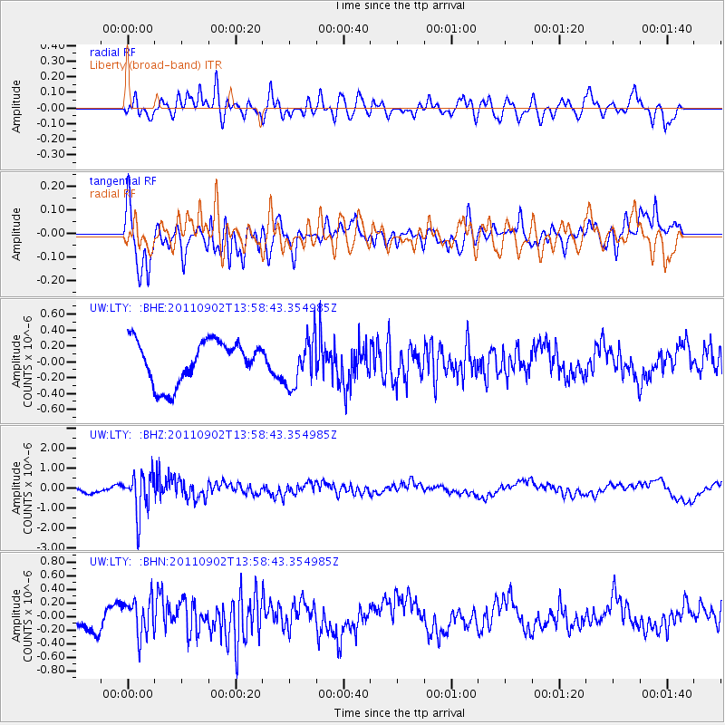
LTY Liberty (broad-band) - Earthquake Result Viewer
*The percent match for this event was below the threshold and hence no stack was calculated.
| Earthquake location: |
Santiago Del Estero Prov., Arg. |
| Earthquake latitude/longitude: |
-28.4/-63.0 |
| Earthquake time(UTC): |
2011/09/02 (245) 13:47:09 GMT |
| Earthquake Depth: |
579 km |
| Earthquake Magnitude: |
6.4 MB, 6.7 MW, 6.7 MW |
| Earthquake Catalog/Contributor: |
WHDF/NEIC |
|
| Network: |
UW Pacific Northwest Regional Seismic Network |
| Station: |
LTY Liberty (broad-band) |
| Lat/Lon: |
47.26 N/120.66 W |
| Elevation: |
970 m |
|
| Distance: |
91.4 deg |
| Az: |
324.862 deg |
| Baz: |
131.894 deg |
| Ray Param: |
$rayparam |
*The percent match for this event was below the threshold and hence was not used in the summary stack. |
|
| Radial Match: |
60.35111 % |
| Radial Bump: |
400 |
| Transverse Match: |
59.78957 % |
| Transverse Bump: |
400 |
| SOD ConfigId: |
414626 |
| Insert Time: |
2012-01-18 09:28:48.533 +0000 |
| GWidth: |
2.5 |
| Max Bumps: |
400 |
| Tol: |
0.001 |
|
Signal To Noise
| Channel | StoN | STA | LTA |
| UW:LTY: :BHZ:20110902T13:58:43.354985Z | 4.120222 | 1.0158077E-6 | 2.46542E-7 |
| UW:LTY: :BHN:20110902T13:58:43.354985Z | 2.267375 | 2.7773615E-7 | 1.2249238E-7 |
| UW:LTY: :BHE:20110902T13:58:43.354985Z | 1.1254331 | 3.0130593E-7 | 2.6772443E-7 |
| Arrivals |
| Ps | |
| PpPs | |
| PsPs/PpSs | |


