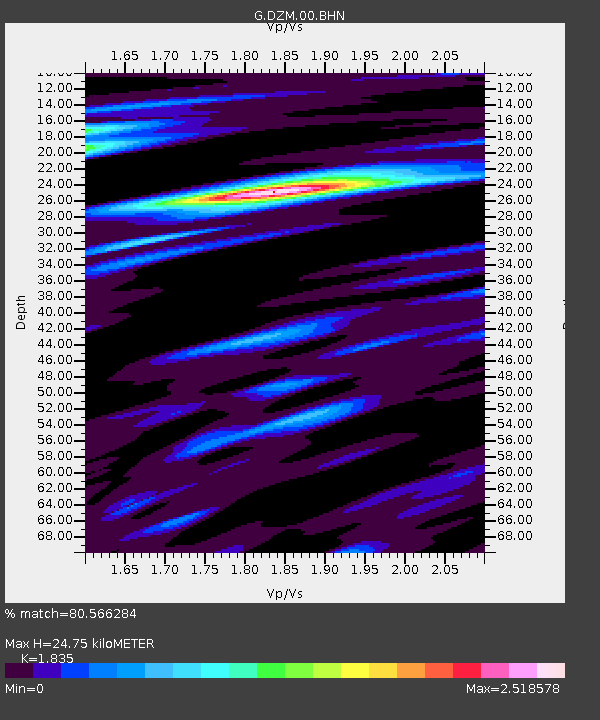
DZM Dzumac, New Caledonia - Earthquake Result Viewer
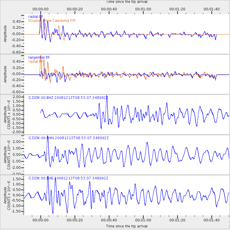
Earthquake location: Western Indian-Antarctic Ridge
Earthquake latitude/longitude: -49.0/123.4
Earthquake time(UTC): 2008/12/13 (348) 08:45:36 GMT
Earthquake Depth: 10 km
Earthquake Magnitude: 6.0 MB, 5.8 MS, 5.9 MW, 5.9 MW
Earthquake Catalog/Contributor: WHDF/NEIC
Network: G GEOSCOPE
Station: DZM Dzumac, New Caledonia
Lat/Lon: 22.07 S/166.44 E
Elevation: 878 m
Distance: 43.3 deg
Az: 67.378 deg
Baz: 220.965 deg
Ray Param: 0.07263555
Estimated Moho Depth: 24.75 km
Estimated Crust Vp/Vs: 1.84
Assumed Crust Vp: 5.14 km/s
Estimated Crust Vs: 2.801 km/s
Estimated Crust Poisson's Ratio: 0.29
Radial Match: 80.566284 %
Radial Bump: 400
Transverse Match: 47.834763 %
Transverse Bump: 400
SOD ConfigId: 2658
Insert Time: 2010-02-26 22:18:08.381 +0000
GWidth: 2.5
Max Bumps: 400
Tol: 0.001

Signal To Noise

ChannelStoNSTALTA
G:DZM:00:BHN:20081213T08:53:07.348992Z4.0399611.0685197E-62.6448765E-7
G:DZM:00:BHE:20081213T08:53:07.348992Z2.93833236.548804E-72.2287486E-7
G:DZM:00:BHZ:20081213T08:53:07.348992Z1.96888534.4367306E-72.2534226E-7
Arrivals
Ps4.2 SECOND
PpPs13 SECOND
PsPs/PpSs17 SECOND