You are here: Home > Network List > UW - Pacific Northwest Regional Seismic Network Stations List
> Station OMAK Colville Reservation, Omak, WA, USA > Earthquake Result Viewer
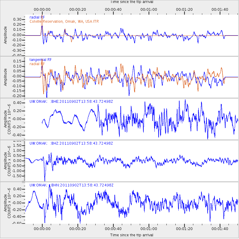
OMAK Colville Reservation, Omak, WA, USA - Earthquake Result Viewer
*The percent match for this event was below the threshold and hence no stack was calculated.
| Earthquake location: |
Santiago Del Estero Prov., Arg. |
| Earthquake latitude/longitude: |
-28.4/-63.0 |
| Earthquake time(UTC): |
2011/09/02 (245) 13:47:09 GMT |
| Earthquake Depth: |
579 km |
| Earthquake Magnitude: |
6.4 MB, 6.7 MW, 6.7 MW |
| Earthquake Catalog/Contributor: |
WHDF/NEIC |
|
| Network: |
UW Pacific Northwest Regional Seismic Network |
| Station: |
OMAK Colville Reservation, Omak, WA, USA |
| Lat/Lon: |
48.36 N/119.33 W |
| Elevation: |
696 m |
|
| Distance: |
91.5 deg |
| Az: |
326.282 deg |
| Baz: |
132.841 deg |
| Ray Param: |
$rayparam |
*The percent match for this event was below the threshold and hence was not used in the summary stack. |
|
| Radial Match: |
50.40244 % |
| Radial Bump: |
400 |
| Transverse Match: |
61.217663 % |
| Transverse Bump: |
400 |
| SOD ConfigId: |
414626 |
| Insert Time: |
2012-01-18 09:29:37.584 +0000 |
| GWidth: |
2.5 |
| Max Bumps: |
400 |
| Tol: |
0.001 |
|
Signal To Noise
| Channel | StoN | STA | LTA |
| UW:OMAK: :BHZ:20110902T13:58:43.72498Z | 2.2039 | 6.1708016E-7 | 2.799946E-7 |
| UW:OMAK: :BHN:20110902T13:58:43.72498Z | 1.7393949 | 2.6521676E-7 | 1.5247645E-7 |
| UW:OMAK: :BHE:20110902T13:58:43.72498Z | 1.3273097 | 1.763194E-7 | 1.3283969E-7 |
| Arrivals |
| Ps | |
| PpPs | |
| PsPs/PpSs | |


