You are here: Home > Network List > UW - Pacific Northwest Regional Seismic Network Stations List
> Station LEBA Lebam, WA, USA > Earthquake Result Viewer
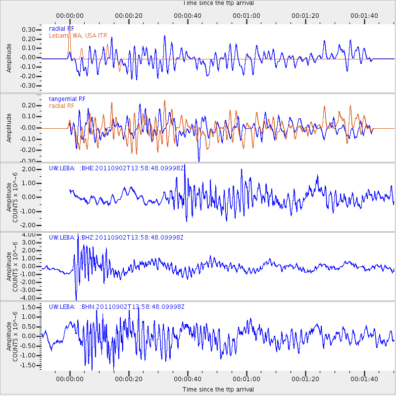
LEBA Lebam, WA, USA - Earthquake Result Viewer
*The percent match for this event was below the threshold and hence no stack was calculated.
| Earthquake location: |
Santiago Del Estero Prov., Arg. |
| Earthquake latitude/longitude: |
-28.4/-63.0 |
| Earthquake time(UTC): |
2011/09/02 (245) 13:47:09 GMT |
| Earthquake Depth: |
579 km |
| Earthquake Magnitude: |
6.4 MB, 6.7 MW, 6.7 MW |
| Earthquake Catalog/Contributor: |
WHDF/NEIC |
|
| Network: |
UW Pacific Northwest Regional Seismic Network |
| Station: |
LEBA Lebam, WA, USA |
| Lat/Lon: |
46.55 N/123.56 W |
| Elevation: |
73 m |
|
| Distance: |
92.5 deg |
| Az: |
323.023 deg |
| Baz: |
129.847 deg |
| Ray Param: |
$rayparam |
*The percent match for this event was below the threshold and hence was not used in the summary stack. |
|
| Radial Match: |
74.841576 % |
| Radial Bump: |
400 |
| Transverse Match: |
70.41912 % |
| Transverse Bump: |
400 |
| SOD ConfigId: |
414626 |
| Insert Time: |
2012-01-18 09:30:18.085 +0000 |
| GWidth: |
2.5 |
| Max Bumps: |
400 |
| Tol: |
0.001 |
|
Signal To Noise
| Channel | StoN | STA | LTA |
| UW:LEBA: :BHZ:20110902T13:58:48.09998Z | 4.386093 | 1.7923493E-6 | 4.0864367E-7 |
| UW:LEBA: :BHN:20110902T13:58:48.09998Z | 1.8447237 | 5.469178E-7 | 2.9647683E-7 |
| UW:LEBA: :BHE:20110902T13:58:48.09998Z | 1.0101825 | 3.1706855E-7 | 3.1387253E-7 |
| Arrivals |
| Ps | |
| PpPs | |
| PsPs/PpSs | |


