You are here: Home > Network List > G - GEOSCOPE Stations List
> Station DZM Dzumac, New Caledonia > Earthquake Result Viewer
DZM Dzumac, New Caledonia - Earthquake Result Viewer
| Earthquake location: |
Kuril Islands |
| Earthquake latitude/longitude: |
46.5/153.2 |
| Earthquake time(UTC): |
2006/10/01 (274) 09:06:02 GMT |
| Earthquake Depth: |
19 km |
| Earthquake Magnitude: |
6.1 MB, 6.4 MS, 6.6 MW, 6.5 MW |
| Earthquake Catalog/Contributor: |
WHDF/NEIC |
|
| Network: |
G GEOSCOPE |
| Station: |
DZM Dzumac, New Caledonia |
| Lat/Lon: |
22.07 S/166.44 E |
| Elevation: |
878 m |
|
| Distance: |
69.3 deg |
| Az: |
166.905 deg |
| Baz: |
350.281 deg |
| Ray Param: |
0.055748567 |
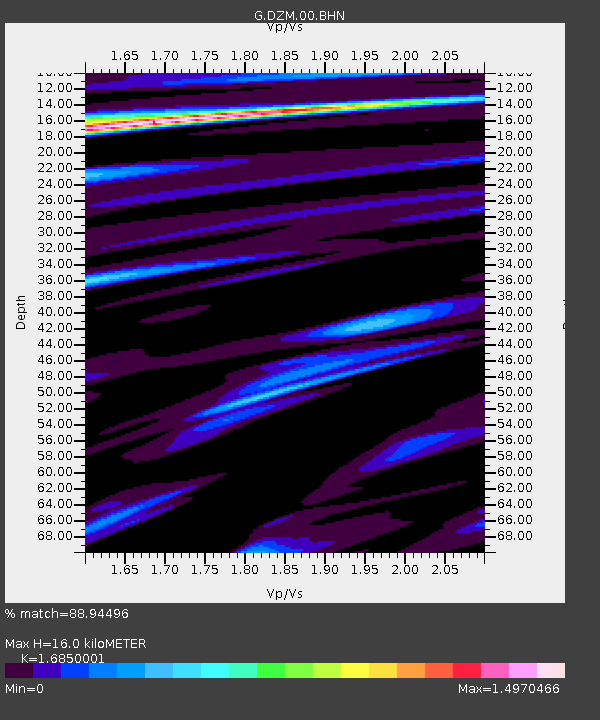
| Estimated Moho Depth: |
16.0 km |
| Estimated Crust Vp/Vs: |
1.69 |
| Assumed Crust Vp: |
5.14 km/s |
| Estimated Crust Vs: |
3.05 km/s |
| Estimated Crust Poisson's Ratio: |
0.23 |
|
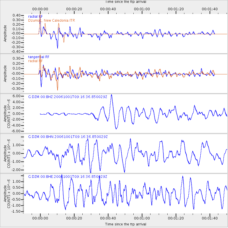
| Radial Match: |
88.94496 % |
| Radial Bump: |
400 |
| Transverse Match: |
85.013435 % |
| Transverse Bump: |
400 |
| SOD ConfigId: |
2665 |
| Insert Time: |
2010-02-26 22:18:14.056 +0000 |
| GWidth: |
2.5 |
| Max Bumps: |
400 |
| Tol: |
0.001 |
|
Signal To Noise
| Channel | StoN | STA | LTA |
| G:DZM:00:BHN:20061001T09:16:36.850029Z | 1.5719429 | 4.5144077E-7 | 2.871865E-7 |
| G:DZM:00:BHE:20061001T09:16:36.850029Z | 3.056732 | 3.3058708E-7 | 1.0815049E-7 |
| G:DZM:00:BHZ:20061001T09:16:36.850029Z | 5.5722094 | 1.1164909E-6 | 2.0036772E-7 |
| Arrivals |
| Ps | 2.2 SECOND |
| PpPs | 8.2 SECOND |
| PsPs/PpSs | 10 SECOND |


