You are here: Home > Network List > TA - USArray Transportable Network (new EarthScope stations) Stations List
> Station R11A Troy Canyon, Currant, NV, USA > Earthquake Result Viewer
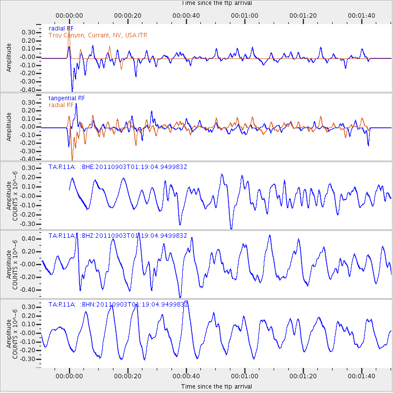
R11A Troy Canyon, Currant, NV, USA - Earthquake Result Viewer
*The percent match for this event was below the threshold and hence no stack was calculated.
| Earthquake location: |
Santa Cruz Islands |
| Earthquake latitude/longitude: |
-12.8/166.8 |
| Earthquake time(UTC): |
2011/09/03 (246) 01:06:53 GMT |
| Earthquake Depth: |
85 km |
| Earthquake Magnitude: |
5.6 MB, 5.8 MW, 5.8 MW |
| Earthquake Catalog/Contributor: |
WHDF/NEIC |
|
| Network: |
TA USArray Transportable Network (new EarthScope stations) |
| Station: |
R11A Troy Canyon, Currant, NV, USA |
| Lat/Lon: |
38.35 N/115.59 W |
| Elevation: |
1756 m |
|
| Distance: |
88.4 deg |
| Az: |
50.203 deg |
| Baz: |
252.414 deg |
| Ray Param: |
$rayparam |
*The percent match for this event was below the threshold and hence was not used in the summary stack. |
|
| Radial Match: |
67.16606 % |
| Radial Bump: |
400 |
| Transverse Match: |
72.33449 % |
| Transverse Bump: |
400 |
| SOD ConfigId: |
414626 |
| Insert Time: |
2012-01-20 08:42:32.079 +0000 |
| GWidth: |
2.5 |
| Max Bumps: |
400 |
| Tol: |
0.001 |
|
Signal To Noise
| Channel | StoN | STA | LTA |
| TA:R11A: :BHZ:20110903T01:19:04.949983Z | 2.2461011 | 2.3712174E-7 | 1.0557037E-7 |
| TA:R11A: :BHN:20110903T01:19:04.949983Z | 2.2361825 | 1.494673E-7 | 6.684038E-8 |
| TA:R11A: :BHE:20110903T01:19:04.949983Z | 1.0433428 | 1.0645992E-7 | 1.0203734E-7 |
| Arrivals |
| Ps | |
| PpPs | |
| PsPs/PpSs | |


