You are here: Home > Network List > TA - USArray Transportable Network (new EarthScope stations) Stations List
> Station G05D Wamic, OR, USA > Earthquake Result Viewer
G05D Wamic, OR, USA - Earthquake Result Viewer
*The percent match for this event was below the threshold and hence no stack was calculated.
| Earthquake location: |
Santa Cruz Islands |
| Earthquake latitude/longitude: |
-12.8/166.8 |
| Earthquake time(UTC): |
2011/09/03 (246) 01:06:53 GMT |
| Earthquake Depth: |
85 km |
| Earthquake Magnitude: |
5.6 MB, 5.8 MW, 5.8 MW |
| Earthquake Catalog/Contributor: |
WHDF/NEIC |
|
| Network: |
TA USArray Transportable Network (new EarthScope stations) |
| Station: |
G05D Wamic, OR, USA |
| Lat/Lon: |
45.24 N/121.32 W |
| Elevation: |
592 m |
|
| Distance: |
86.6 deg |
| Az: |
42.273 deg |
| Baz: |
248.253 deg |
| Ray Param: |
$rayparam |
*The percent match for this event was below the threshold and hence was not used in the summary stack. |
|
| Radial Match: |
51.163715 % |
| Radial Bump: |
400 |
| Transverse Match: |
51.497246 % |
| Transverse Bump: |
400 |
| SOD ConfigId: |
414626 |
| Insert Time: |
2012-01-20 08:43:10.653 +0000 |
| GWidth: |
2.5 |
| Max Bumps: |
400 |
| Tol: |
0.001 |
|
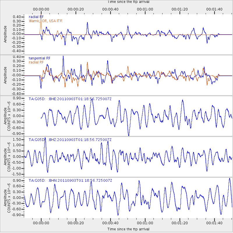
Signal To Noise
| Channel | StoN | STA | LTA |
| TA:G05D: :BHZ:20110903T01:18:56.725007Z | 2.3021593 | 8.165181E-7 | 3.5467485E-7 |
| TA:G05D: :BHN:20110903T01:18:56.725007Z | 0.9819628 | 3.0554406E-7 | 3.1115644E-7 |
| TA:G05D: :BHE:20110903T01:18:56.725007Z | 1.5080768 | 4.279311E-7 | 2.8375948E-7 |
| Arrivals |
| Ps | |
| PpPs | |
| PsPs/PpSs | |


