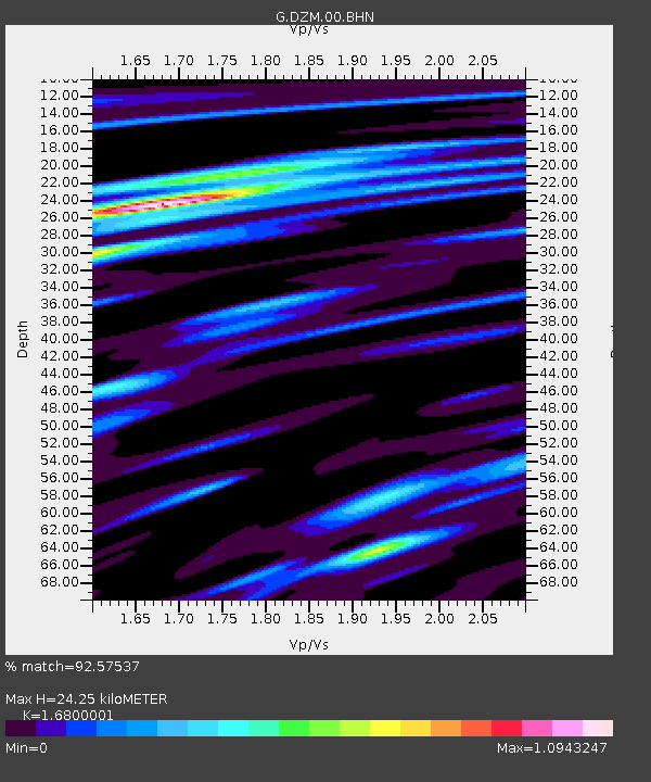
DZM Dzumac, New Caledonia - Earthquake Result Viewer
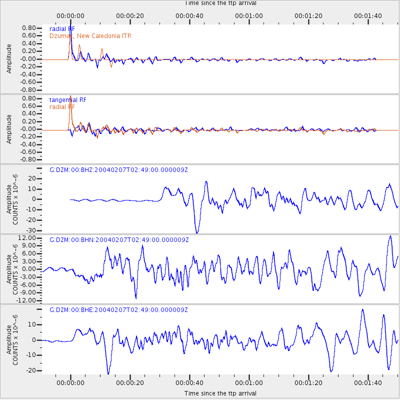
Earthquake location: Irian Jaya Region, Indonesia
Earthquake latitude/longitude: -4.0/135.0
Earthquake time(UTC): 2004/02/07 (038) 02:42:35 GMT
Earthquake Depth: 10 km
Earthquake Magnitude: 6.2 MB, 7.5 MS, 7.3 MW, 7.3 MW
Earthquake Catalog/Contributor: WHDF/NEIC
Network: G GEOSCOPE
Station: DZM Dzumac, New Caledonia
Lat/Lon: 22.07 S/166.44 E
Elevation: 878 m
Distance: 35.4 deg
Az: 123.314 deg
Baz: 296.007 deg
Ray Param: 0.07726695
Estimated Moho Depth: 24.25 km
Estimated Crust Vp/Vs: 1.68
Assumed Crust Vp: 5.14 km/s
Estimated Crust Vs: 3.06 km/s
Estimated Crust Poisson's Ratio: 0.23
Radial Match: 92.57537 %
Radial Bump: 308
Transverse Match: 77.6841 %
Transverse Bump: 400
SOD ConfigId: 2459
Insert Time: 2010-02-26 22:18:32.559 +0000
GWidth: 2.5
Max Bumps: 400
Tol: 0.001

Signal To Noise

ChannelStoNSTALTA
G:DZM:00:BHN:20040207T02:49:00.000009Z4.6711342.1027588E-64.5016023E-7
G:DZM:00:BHE:20040207T02:49:00.000009Z8.60614.8225097E-65.6035947E-7
G:DZM:00:BHZ:20040207T02:49:00.000009Z13.093147.445779E-65.686779E-7
Arrivals
Ps3.4 SECOND
PpPs12 SECOND
PsPs/PpSs15 SECOND