You are here: Home > Network List > TA - USArray Transportable Network (new EarthScope stations) Stations List
> Station 334A Lometa, TX, USA > Earthquake Result Viewer
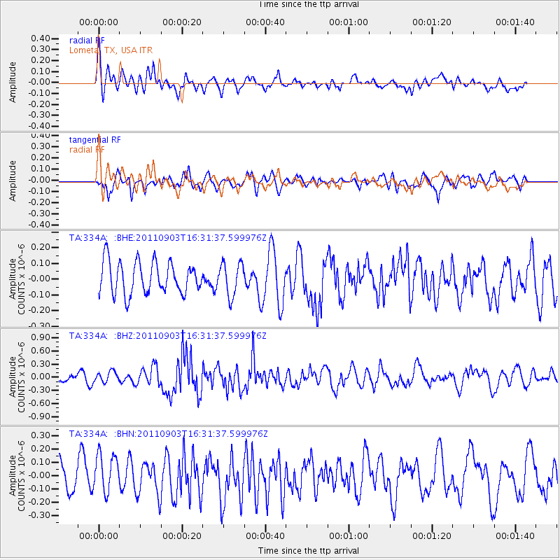
334A Lometa, TX, USA - Earthquake Result Viewer
*The percent match for this event was below the threshold and hence no stack was calculated.
| Earthquake location: |
Off Coast Of Central Chile |
| Earthquake latitude/longitude: |
-38.4/-74.9 |
| Earthquake time(UTC): |
2011/09/03 (246) 16:20:41 GMT |
| Earthquake Depth: |
12 km |
| Earthquake Magnitude: |
5.5 MB, 5.5 MS, 5.8 MW, 5.7 MW |
| Earthquake Catalog/Contributor: |
WHDF/NEIC |
|
| Network: |
TA USArray Transportable Network (new EarthScope stations) |
| Station: |
334A Lometa, TX, USA |
| Lat/Lon: |
31.33 N/98.24 W |
| Elevation: |
389 m |
|
| Distance: |
72.7 deg |
| Az: |
339.214 deg |
| Baz: |
160.992 deg |
| Ray Param: |
$rayparam |
*The percent match for this event was below the threshold and hence was not used in the summary stack. |
|
| Radial Match: |
55.785503 % |
| Radial Bump: |
400 |
| Transverse Match: |
58.900482 % |
| Transverse Bump: |
400 |
| SOD ConfigId: |
414626 |
| Insert Time: |
2012-01-20 09:12:31.212 +0000 |
| GWidth: |
2.5 |
| Max Bumps: |
400 |
| Tol: |
0.001 |
|
Signal To Noise
| Channel | StoN | STA | LTA |
| TA:334A: :BHZ:20110903T16:31:37.599976Z | 1.7306293 | 1.2306613E-7 | 7.111063E-8 |
| TA:334A: :BHN:20110903T16:31:37.599976Z | 1.3466058 | 1.5969614E-7 | 1.185916E-7 |
| TA:334A: :BHE:20110903T16:31:37.599976Z | 1.0647095 | 1.0753253E-7 | 1.0099706E-7 |
| Arrivals |
| Ps | |
| PpPs | |
| PsPs/PpSs | |


