You are here: Home > Network List > TA - USArray Transportable Network (new EarthScope stations) Stations List
> Station R36A Gordon, Harris, KS, USA > Earthquake Result Viewer
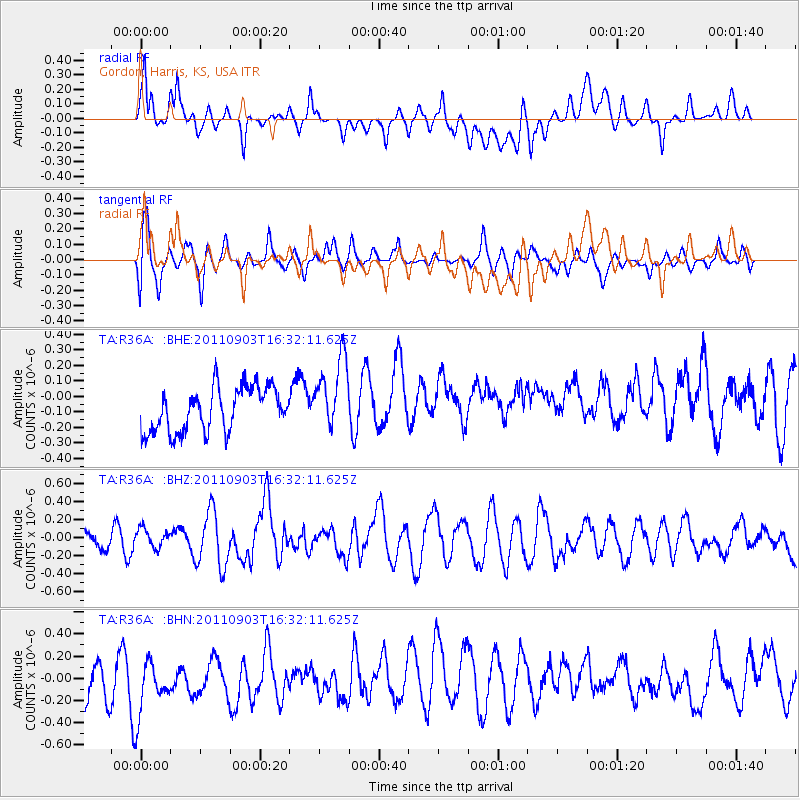
R36A Gordon, Harris, KS, USA - Earthquake Result Viewer
*The percent match for this event was below the threshold and hence no stack was calculated.
| Earthquake location: |
Off Coast Of Central Chile |
| Earthquake latitude/longitude: |
-38.4/-74.9 |
| Earthquake time(UTC): |
2011/09/03 (246) 16:20:41 GMT |
| Earthquake Depth: |
12 km |
| Earthquake Magnitude: |
5.5 MB, 5.5 MS, 5.8 MW, 5.7 MW |
| Earthquake Catalog/Contributor: |
WHDF/NEIC |
|
| Network: |
TA USArray Transportable Network (new EarthScope stations) |
| Station: |
R36A Gordon, Harris, KS, USA |
| Lat/Lon: |
38.32 N/95.50 W |
| Elevation: |
354 m |
|
| Distance: |
78.7 deg |
| Az: |
343.61 deg |
| Baz: |
163.636 deg |
| Ray Param: |
$rayparam |
*The percent match for this event was below the threshold and hence was not used in the summary stack. |
|
| Radial Match: |
48.76384 % |
| Radial Bump: |
400 |
| Transverse Match: |
63.680626 % |
| Transverse Bump: |
400 |
| SOD ConfigId: |
414626 |
| Insert Time: |
2012-01-20 09:13:36.094 +0000 |
| GWidth: |
2.5 |
| Max Bumps: |
400 |
| Tol: |
0.001 |
|
Signal To Noise
| Channel | StoN | STA | LTA |
| TA:R36A: :BHZ:20110903T16:32:11.625Z | 0.6217534 | 1.03277124E-7 | 1.6610625E-7 |
| TA:R36A: :BHN:20110903T16:32:11.625Z | 1.2298111 | 3.2015748E-7 | 2.6033064E-7 |
| TA:R36A: :BHE:20110903T16:32:11.625Z | 1.6840748 | 2.3660114E-7 | 1.4049324E-7 |
| Arrivals |
| Ps | |
| PpPs | |
| PsPs/PpSs | |


