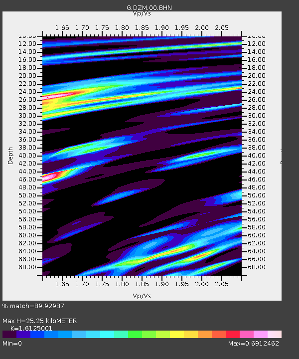
DZM Dzumac, New Caledonia - Earthquake Result Viewer
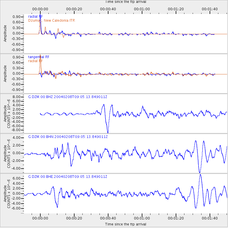
Earthquake location: Irian Jaya Region, Indonesia
Earthquake latitude/longitude: -3.7/135.3
Earthquake time(UTC): 2004/02/08 (039) 08:58:51 GMT
Earthquake Depth: 26 km
Earthquake Magnitude: 5.7 MB, 6.9 MS, 6.7 MW, 6.5 MW
Earthquake Catalog/Contributor: WHDF/NEIC
Network: G GEOSCOPE
Station: DZM Dzumac, New Caledonia
Lat/Lon: 22.07 S/166.44 E
Elevation: 878 m
Distance: 35.3 deg
Az: 123.934 deg
Baz: 296.792 deg
Ray Param: 0.07726762
Estimated Moho Depth: 25.25 km
Estimated Crust Vp/Vs: 1.61
Assumed Crust Vp: 5.14 km/s
Estimated Crust Vs: 3.188 km/s
Estimated Crust Poisson's Ratio: 0.19
Radial Match: 89.92987 %
Radial Bump: 316
Transverse Match: 69.178406 %
Transverse Bump: 400
SOD ConfigId: 2459
Insert Time: 2010-02-26 22:18:33.950 +0000
GWidth: 2.5
Max Bumps: 400
Tol: 0.001

Signal To Noise

ChannelStoNSTALTA
G:DZM:00:BHN:20040208T09:05:13.849011Z0.67021381.9691497E-72.9380917E-7
G:DZM:00:BHE:20040208T09:05:13.849011Z1.68970194.522363E-72.6764263E-7
G:DZM:00:BHZ:20040208T09:05:13.849011Z2.00194126.9401267E-73.4666985E-7
Arrivals
Ps3.2 SECOND
PpPs12 SECOND
PsPs/PpSs15 SECOND