You are here: Home > Network List > AU - Australian Seismological Centre Stations List
> Station KMBL Kambalda, Western Australia > Earthquake Result Viewer
KMBL Kambalda, Western Australia - Earthquake Result Viewer
| Earthquake location: |
Vanuatu Islands |
| Earthquake latitude/longitude: |
-20.7/169.7 |
| Earthquake time(UTC): |
2011/09/03 (246) 22:55:40 GMT |
| Earthquake Depth: |
185 km |
| Earthquake Magnitude: |
6.4 MB, 7.0 MW, 7.0 MW |
| Earthquake Catalog/Contributor: |
WHDF/NEIC |
|
| Network: |
AU Australian Seismological Centre |
| Station: |
KMBL Kambalda, Western Australia |
| Lat/Lon: |
31.37 S/121.88 E |
| Elevation: |
370 m |
|
| Distance: |
44.0 deg |
| Az: |
245.907 deg |
| Baz: |
87.904 deg |
| Ray Param: |
0.071499735 |
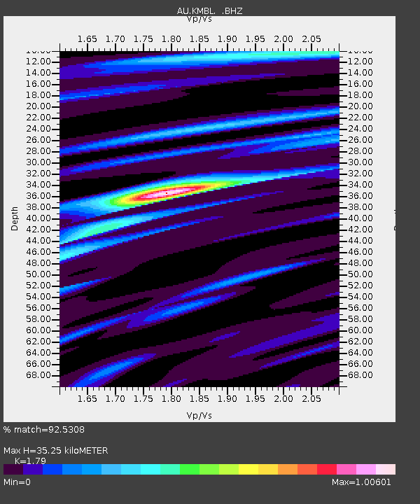
| Estimated Moho Depth: |
35.25 km |
| Estimated Crust Vp/Vs: |
1.79 |
| Assumed Crust Vp: |
6.459 km/s |
| Estimated Crust Vs: |
3.609 km/s |
| Estimated Crust Poisson's Ratio: |
0.27 |
|
| Radial Match: |
92.5308 % |
| Radial Bump: |
240 |
| Transverse Match: |
59.44036 % |
| Transverse Bump: |
400 |
| SOD ConfigId: |
414626 |
| Insert Time: |
2012-01-20 09:34:15.082 +0000 |
| GWidth: |
2.5 |
| Max Bumps: |
400 |
| Tol: |
0.001 |
|

Signal To Noise
| Channel | StoN | STA | LTA |
| AU:KMBL: :BHZ:20110903T23:02:59.295Z | 16.782793 | 1.1319212E-5 | 6.7445336E-7 |
| AU:KMBL: :BHN:20110903T23:02:59.295Z | 2.2422423 | 1.0598391E-6 | 4.7266929E-7 |
| AU:KMBL: :BHE:20110903T23:02:59.295Z | 21.757488 | 7.13961E-6 | 3.2814492E-7 |
| Arrivals |
| Ps | 4.6 SECOND |
| PpPs | 14 SECOND |
| PsPs/PpSs | 19 SECOND |


