You are here: Home > Network List > BK - Berkeley Digital Seismograph Network Stations List
> Station SAO San Andreas Geophysical Obs., Hollister, CA, USA > Earthquake Result Viewer
SAO San Andreas Geophysical Obs., Hollister, CA, USA - Earthquake Result Viewer

| Earthquake location: |
Vanuatu Islands |
| Earthquake latitude/longitude: |
-20.7/169.7 |
| Earthquake time(UTC): |
2011/09/03 (246) 22:55:40 GMT |
| Earthquake Depth: |
185 km |
| Earthquake Magnitude: |
6.4 MB, 7.0 MW, 7.0 MW |
| Earthquake Catalog/Contributor: |
WHDF/NEIC |
|
| Network: |
BK Berkeley Digital Seismograph Network |
| Station: |
SAO San Andreas Geophysical Obs., Hollister, CA, USA |
| Lat/Lon: |
36.76 N/121.45 W |
| Elevation: |
317 m |
|
| Distance: |
86.4 deg |
| Az: |
48.619 deg |
| Baz: |
241.039 deg |
| Ray Param: |
0.043628033 |
| Estimated Moho Depth: |
14.0 km |
| Estimated Crust Vp/Vs: |
1.88 |
| Assumed Crust Vp: |
6.391 km/s |
| Estimated Crust Vs: |
3.399 km/s |
| Estimated Crust Poisson's Ratio: |
0.30 |
|
| Radial Match: |
85.983765 % |
| Radial Bump: |
400 |
| Transverse Match: |
88.22739 % |
| Transverse Bump: |
400 |
| SOD ConfigId: |
414626 |
| Insert Time: |
2012-01-20 09:38:20.772 +0000 |
| GWidth: |
2.5 |
| Max Bumps: |
400 |
| Tol: |
0.001 |
|
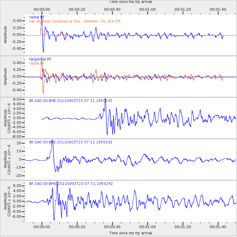
Signal To Noise
| Channel | StoN | STA | LTA |
| BK:SAO:00:BHZ:20110903T23:07:31.195024Z | 8.024116 | 2.4918338E-6 | 3.1054313E-7 |
| BK:SAO:00:BHN:20110903T23:07:31.195024Z | 2.4024787 | 4.741986E-7 | 1.9737891E-7 |
| BK:SAO:00:BHE:20110903T23:07:31.195024Z | 3.3834217 | 8.2988475E-7 | 2.4527972E-7 |
| Arrivals |
| Ps | 2.0 SECOND |
| PpPs | 6.2 SECOND |
| PsPs/PpSs | 8.1 SECOND |


