You are here: Home > Network List > IU - Global Seismograph Network (GSN - IRIS/USGS) Stations List
> Station SLBS Sierra la Laguna Baja California Sur, Mexico > Earthquake Result Viewer
SLBS Sierra la Laguna Baja California Sur, Mexico - Earthquake Result Viewer
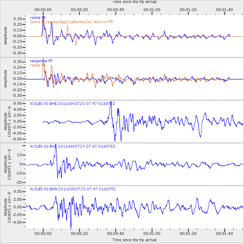
| Earthquake location: |
Vanuatu Islands |
| Earthquake latitude/longitude: |
-20.7/169.7 |
| Earthquake time(UTC): |
2011/09/03 (246) 22:55:40 GMT |
| Earthquake Depth: |
185 km |
| Earthquake Magnitude: |
6.4 MB, 7.0 MW, 7.0 MW |
| Earthquake Catalog/Contributor: |
WHDF/NEIC |
|
| Network: |
IU Global Seismograph Network (GSN - IRIS/USGS) |
| Station: |
SLBS Sierra la Laguna Baja California Sur, Mexico |
| Lat/Lon: |
23.69 N/109.94 W |
| Elevation: |
825 m |
|
| Distance: |
89.8 deg |
| Az: |
64.656 deg |
| Baz: |
247.388 deg |
| Ray Param: |
0.041680306 |
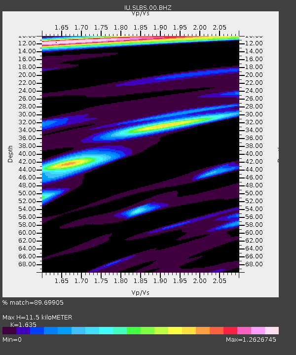
| Estimated Moho Depth: |
11.5 km |
| Estimated Crust Vp/Vs: |
1.63 |
| Assumed Crust Vp: |
6.183 km/s |
| Estimated Crust Vs: |
3.781 km/s |
| Estimated Crust Poisson's Ratio: |
0.20 |
|
| Radial Match: |
89.69905 % |
| Radial Bump: |
400 |
| Transverse Match: |
87.99039 % |
| Transverse Bump: |
400 |
| SOD ConfigId: |
414626 |
| Insert Time: |
2012-01-20 09:49:08.980 +0000 |
| GWidth: |
2.5 |
| Max Bumps: |
400 |
| Tol: |
0.001 |
|
Signal To Noise
| Channel | StoN | STA | LTA |
| IU:SLBS:00:BHZ:20110903T23:07:47.019976Z | 3.1643016 | 1.2311318E-6 | 3.8906904E-7 |
| IU:SLBS:00:BHN:20110903T23:07:47.019976Z | 1.1772139 | 4.4359356E-7 | 3.7681642E-7 |
| IU:SLBS:00:BHE:20110903T23:07:47.019976Z | 1.4949588 | 3.6156635E-7 | 2.418571E-7 |
| Arrivals |
| Ps | 1.2 SECOND |
| PpPs | 4.8 SECOND |
| PsPs/PpSs | 6.0 SECOND |


