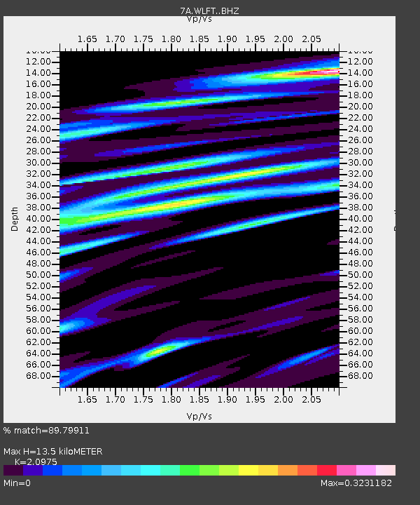
WLFT Gordonsville, Virginia USA - Earthquake Result Viewer

Earthquake location: Near Coast Of Northern Chile
Earthquake latitude/longitude: -20.2/-70.9
Earthquake time(UTC): 2014/04/07 (097) 13:43:20 GMT
Earthquake Depth: 7.9 km
Earthquake Magnitude: 5.8 MWB, 5.7 MWW, 5.7 MWC
Earthquake Catalog/Contributor: NEIC PDE/NEIC COMCAT
Network: 7A Mid-Atlantic Geophysical Integrative Collaboration
Station: WLFT Gordonsville, Virginia USA
Lat/Lon: 38.17 N/78.14 W
Elevation: 110 m
Distance: 58.4 deg
Az: 353.269 deg
Baz: 171.97 deg
Ray Param: 0.0628653
Estimated Moho Depth: 13.5 km
Estimated Crust Vp/Vs: 2.10
Assumed Crust Vp: 6.159 km/s
Estimated Crust Vs: 2.936 km/s
Estimated Crust Poisson's Ratio: 0.35
Radial Match: 89.79911 %
Radial Bump: 323
Transverse Match: 57.026333 %
Transverse Bump: 400
SOD ConfigId: 3390531
Insert Time: 2019-04-11 05:10:25.374 +0000
GWidth: 2.5
Max Bumps: 400
Tol: 0.001

Signal To Noise

ChannelStoNSTALTA
7A:WLFT: :BHZ:20140407T13:52:45.375024Z5.35812959.237209E-71.7239616E-7
7A:WLFT: :BHN:20140407T13:52:45.375024Z3.16049244.627899E-71.4642968E-7
7A:WLFT: :BHE:20140407T13:52:45.375024Z1.11232471.5405818E-71.385011E-7
Arrivals
Ps2.5 SECOND
PpPs6.5 SECOND
PsPs/PpSs9.0 SECOND