You are here: Home > Network List > TA - USArray Transportable Network (new EarthScope stations) Stations List
> Station O03D Paynes Creek, CA, USA > Earthquake Result Viewer
O03D Paynes Creek, CA, USA - Earthquake Result Viewer
| Earthquake location: |
Vanuatu Islands |
| Earthquake latitude/longitude: |
-20.7/169.7 |
| Earthquake time(UTC): |
2011/09/03 (246) 22:55:40 GMT |
| Earthquake Depth: |
185 km |
| Earthquake Magnitude: |
6.4 MB, 7.0 MW, 7.0 MW |
| Earthquake Catalog/Contributor: |
WHDF/NEIC |
|
| Network: |
TA USArray Transportable Network (new EarthScope stations) |
| Station: |
O03D Paynes Creek, CA, USA |
| Lat/Lon: |
40.29 N/121.80 W |
| Elevation: |
968 m |
|
| Distance: |
87.9 deg |
| Az: |
45.401 deg |
| Baz: |
240.659 deg |
| Ray Param: |
0.042558163 |
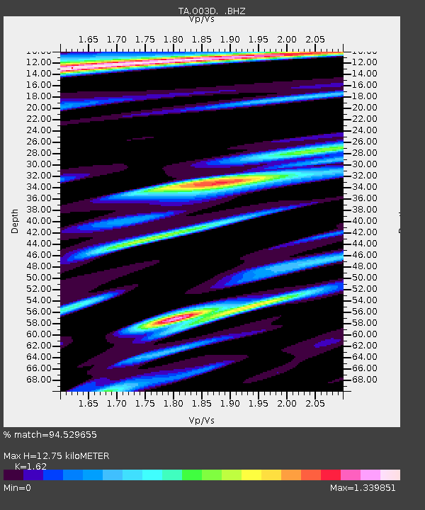
| Estimated Moho Depth: |
12.75 km |
| Estimated Crust Vp/Vs: |
1.62 |
| Assumed Crust Vp: |
6.566 km/s |
| Estimated Crust Vs: |
4.053 km/s |
| Estimated Crust Poisson's Ratio: |
0.19 |
|
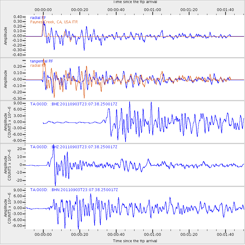
| Radial Match: |
94.529655 % |
| Radial Bump: |
309 |
| Transverse Match: |
94.319855 % |
| Transverse Bump: |
400 |
| SOD ConfigId: |
414626 |
| Insert Time: |
2012-01-20 09:55:43.866 +0000 |
| GWidth: |
2.5 |
| Max Bumps: |
400 |
| Tol: |
0.001 |
|
Signal To Noise
| Channel | StoN | STA | LTA |
| TA:O03D: :BHZ:20110903T23:07:38.250017Z | 22.98156 | 3.6957802E-6 | 1.6081503E-7 |
| TA:O03D: :BHN:20110903T23:07:38.250017Z | 2.529059 | 4.0096396E-7 | 1.5854275E-7 |
| TA:O03D: :BHE:20110903T23:07:38.250017Z | 3.4936104 | 7.763879E-7 | 2.2223082E-7 |
| Arrivals |
| Ps | 1.2 SECOND |
| PpPs | 5.0 SECOND |
| PsPs/PpSs | 6.2 SECOND |


