You are here: Home > Network List > TA - USArray Transportable Network (new EarthScope stations) Stations List
> Station I02D Swisshome, OR, USA > Earthquake Result Viewer
I02D Swisshome, OR, USA - Earthquake Result Viewer
| Earthquake location: |
Vanuatu Islands |
| Earthquake latitude/longitude: |
-20.7/169.7 |
| Earthquake time(UTC): |
2011/09/03 (246) 22:55:40 GMT |
| Earthquake Depth: |
185 km |
| Earthquake Magnitude: |
6.4 MB, 7.0 MW, 7.0 MW |
| Earthquake Catalog/Contributor: |
WHDF/NEIC |
|
| Network: |
TA USArray Transportable Network (new EarthScope stations) |
| Station: |
I02D Swisshome, OR, USA |
| Lat/Lon: |
44.11 N/123.85 W |
| Elevation: |
109 m |
|
| Distance: |
88.5 deg |
| Az: |
41.342 deg |
| Baz: |
239.162 deg |
| Ray Param: |
0.042122733 |
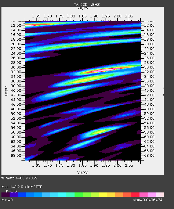
| Estimated Moho Depth: |
12.0 km |
| Estimated Crust Vp/Vs: |
1.60 |
| Assumed Crust Vp: |
6.566 km/s |
| Estimated Crust Vs: |
4.104 km/s |
| Estimated Crust Poisson's Ratio: |
0.18 |
|
| Radial Match: |
86.97359 % |
| Radial Bump: |
400 |
| Transverse Match: |
81.78518 % |
| Transverse Bump: |
400 |
| SOD ConfigId: |
414626 |
| Insert Time: |
2012-01-20 09:56:06.686 +0000 |
| GWidth: |
2.5 |
| Max Bumps: |
400 |
| Tol: |
0.001 |
|
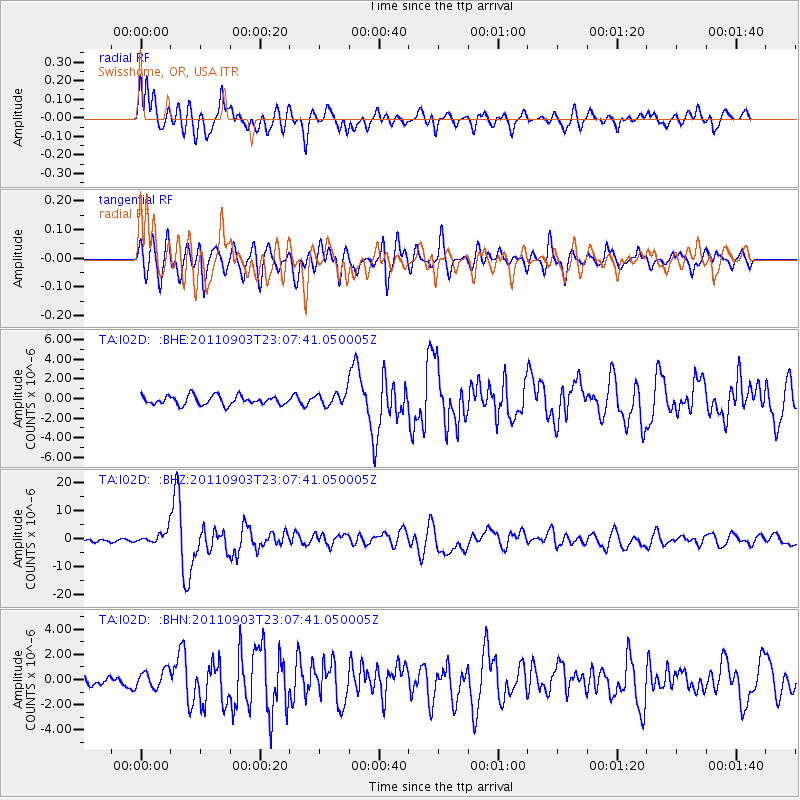
Signal To Noise
| Channel | StoN | STA | LTA |
| TA:I02D: :BHZ:20110903T23:07:41.050005Z | 4.1116757 | 2.2126667E-6 | 5.381423E-7 |
| TA:I02D: :BHN:20110903T23:07:41.050005Z | 2.4069512 | 7.3209026E-7 | 3.0415666E-7 |
| TA:I02D: :BHE:20110903T23:07:41.050005Z | 1.4719993 | 6.696379E-7 | 4.5491728E-7 |
| Arrivals |
| Ps | 1.1 SECOND |
| PpPs | 4.6 SECOND |
| PsPs/PpSs | 5.8 SECOND |


