You are here: Home > Network List > TA - USArray Transportable Network (new EarthScope stations) Stations List
> Station TOLK Tollok Lake Research Station, AK, USA > Earthquake Result Viewer
TOLK Tollok Lake Research Station, AK, USA - Earthquake Result Viewer
| Earthquake location: |
Vanuatu Islands |
| Earthquake latitude/longitude: |
-20.7/169.7 |
| Earthquake time(UTC): |
2011/09/03 (246) 22:55:40 GMT |
| Earthquake Depth: |
185 km |
| Earthquake Magnitude: |
6.4 MB, 7.0 MW, 7.0 MW |
| Earthquake Catalog/Contributor: |
WHDF/NEIC |
|
| Network: |
TA USArray Transportable Network (new EarthScope stations) |
| Station: |
TOLK Tollok Lake Research Station, AK, USA |
| Lat/Lon: |
68.64 N/149.57 W |
| Elevation: |
760 m |
|
| Distance: |
93.8 deg |
| Az: |
13.856 deg |
| Baz: |
217.743 deg |
| Ray Param: |
0.04106023 |
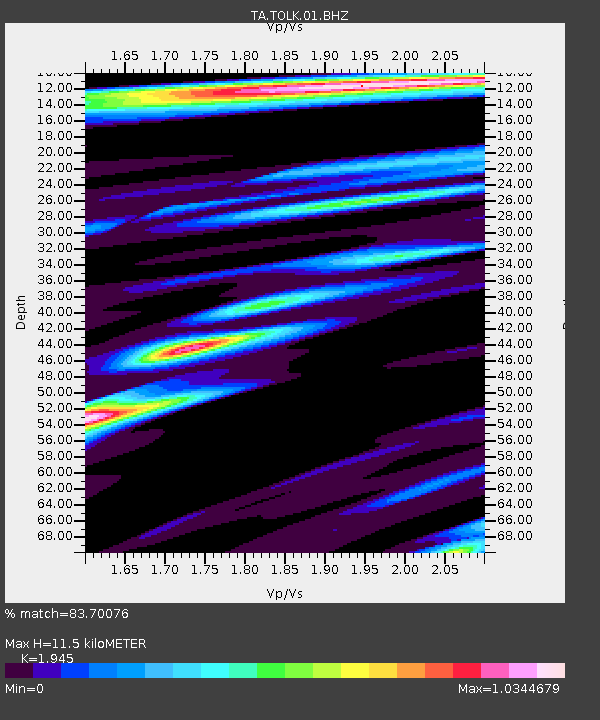
| Estimated Moho Depth: |
11.5 km |
| Estimated Crust Vp/Vs: |
1.95 |
| Assumed Crust Vp: |
6.316 km/s |
| Estimated Crust Vs: |
3.247 km/s |
| Estimated Crust Poisson's Ratio: |
0.32 |
|
| Radial Match: |
83.70076 % |
| Radial Bump: |
400 |
| Transverse Match: |
84.67136 % |
| Transverse Bump: |
400 |
| SOD ConfigId: |
414626 |
| Insert Time: |
2012-01-20 09:57:22.385 +0000 |
| GWidth: |
2.5 |
| Max Bumps: |
400 |
| Tol: |
0.001 |
|

Signal To Noise
| Channel | StoN | STA | LTA |
| TA:TOLK:01:BHZ:20110903T23:08:05.575029Z | 17.001665 | 2.7138315E-6 | 1.5962151E-7 |
| TA:TOLK:01:BHN:20110903T23:08:05.575029Z | 7.207867 | 5.835247E-7 | 8.095664E-8 |
| TA:TOLK:01:BHE:20110903T23:08:05.575029Z | 5.175839 | 4.6269503E-7 | 8.939517E-8 |
| Arrivals |
| Ps | 1.8 SECOND |
| PpPs | 5.3 SECOND |
| PsPs/PpSs | 7.0 SECOND |


