You are here: Home > Network List > TW - Broadband Array in Taiwan for Seismology Stations List
> Station KMNB KING-MEN > Earthquake Result Viewer
KMNB KING-MEN - Earthquake Result Viewer
| Earthquake location: |
Vanuatu Islands |
| Earthquake latitude/longitude: |
-20.7/169.7 |
| Earthquake time(UTC): |
2011/09/03 (246) 22:55:40 GMT |
| Earthquake Depth: |
185 km |
| Earthquake Magnitude: |
6.4 MB, 7.0 MW, 7.0 MW |
| Earthquake Catalog/Contributor: |
WHDF/NEIC |
|
| Network: |
TW Broadband Array in Taiwan for Seismology |
| Station: |
KMNB KING-MEN |
| Lat/Lon: |
24.46 N/118.39 E |
| Elevation: |
43 m |
|
| Distance: |
67.1 deg |
| Az: |
309.451 deg |
| Baz: |
127.489 deg |
| Ray Param: |
0.05663155 |
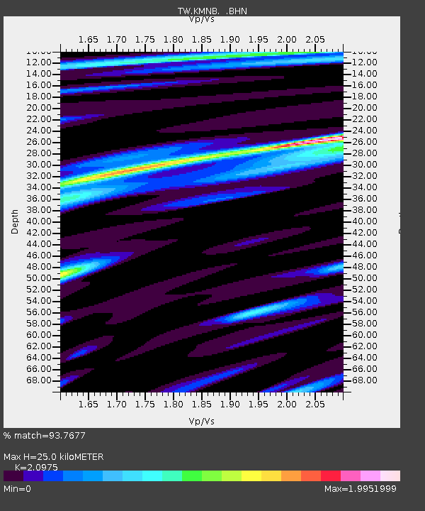
| Estimated Moho Depth: |
25.0 km |
| Estimated Crust Vp/Vs: |
2.10 |
| Assumed Crust Vp: |
6.472 km/s |
| Estimated Crust Vs: |
3.086 km/s |
| Estimated Crust Poisson's Ratio: |
0.35 |
|
| Radial Match: |
93.7677 % |
| Radial Bump: |
400 |
| Transverse Match: |
80.27173 % |
| Transverse Bump: |
400 |
| SOD ConfigId: |
414626 |
| Insert Time: |
2012-01-20 09:58:10.382 +0000 |
| GWidth: |
2.5 |
| Max Bumps: |
400 |
| Tol: |
0.001 |
|

Signal To Noise
| Channel | StoN | STA | LTA |
| TW:KMNB: :BHZ:20110903T23:05:43.719988Z | 6.1360755 | 3.3280992E-6 | 5.423824E-7 |
| TW:KMNB: :BHN:20110903T23:05:43.719988Z | 2.873244 | 1.9096922E-6 | 6.6464673E-7 |
| TW:KMNB: :BHE:20110903T23:05:43.719988Z | 2.5803897 | 2.389492E-6 | 9.260198E-7 |
| Arrivals |
| Ps | 4.4 SECOND |
| PpPs | 12 SECOND |
| PsPs/PpSs | 16 SECOND |


