You are here: Home > Network List > UW - Pacific Northwest Regional Seismic Network Stations List
> Station MEGW Megler, WA CREST BB SMO > Earthquake Result Viewer
MEGW Megler, WA CREST BB SMO - Earthquake Result Viewer
| Earthquake location: |
Vanuatu Islands |
| Earthquake latitude/longitude: |
-20.7/169.7 |
| Earthquake time(UTC): |
2011/09/03 (246) 22:55:40 GMT |
| Earthquake Depth: |
185 km |
| Earthquake Magnitude: |
6.4 MB, 7.0 MW, 7.0 MW |
| Earthquake Catalog/Contributor: |
WHDF/NEIC |
|
| Network: |
UW Pacific Northwest Regional Seismic Network |
| Station: |
MEGW Megler, WA CREST BB SMO |
| Lat/Lon: |
46.27 N/123.88 W |
| Elevation: |
332 m |
|
| Distance: |
89.6 deg |
| Az: |
39.476 deg |
| Baz: |
239.11 deg |
| Ray Param: |
0.04169411 |
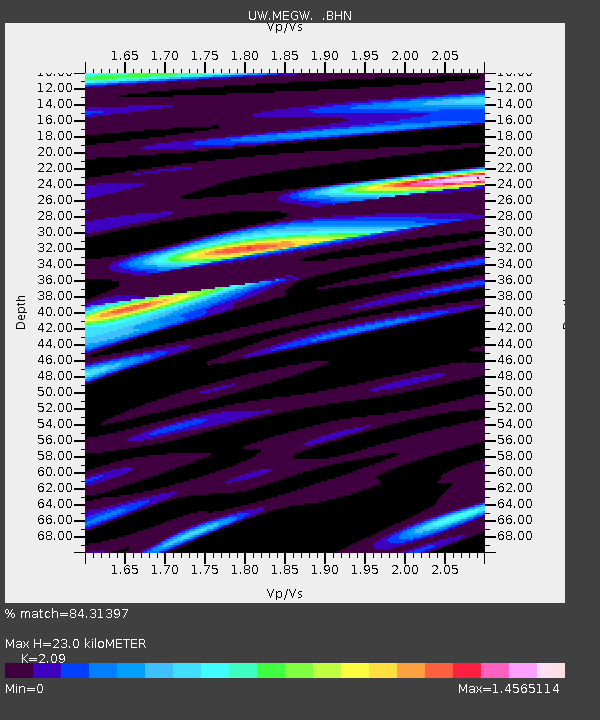
| Estimated Moho Depth: |
23.0 km |
| Estimated Crust Vp/Vs: |
2.09 |
| Assumed Crust Vp: |
6.566 km/s |
| Estimated Crust Vs: |
3.142 km/s |
| Estimated Crust Poisson's Ratio: |
0.35 |
|
| Radial Match: |
84.31397 % |
| Radial Bump: |
400 |
| Transverse Match: |
77.033905 % |
| Transverse Bump: |
400 |
| SOD ConfigId: |
414626 |
| Insert Time: |
2012-01-20 10:00:20.156 +0000 |
| GWidth: |
2.5 |
| Max Bumps: |
400 |
| Tol: |
0.001 |
|
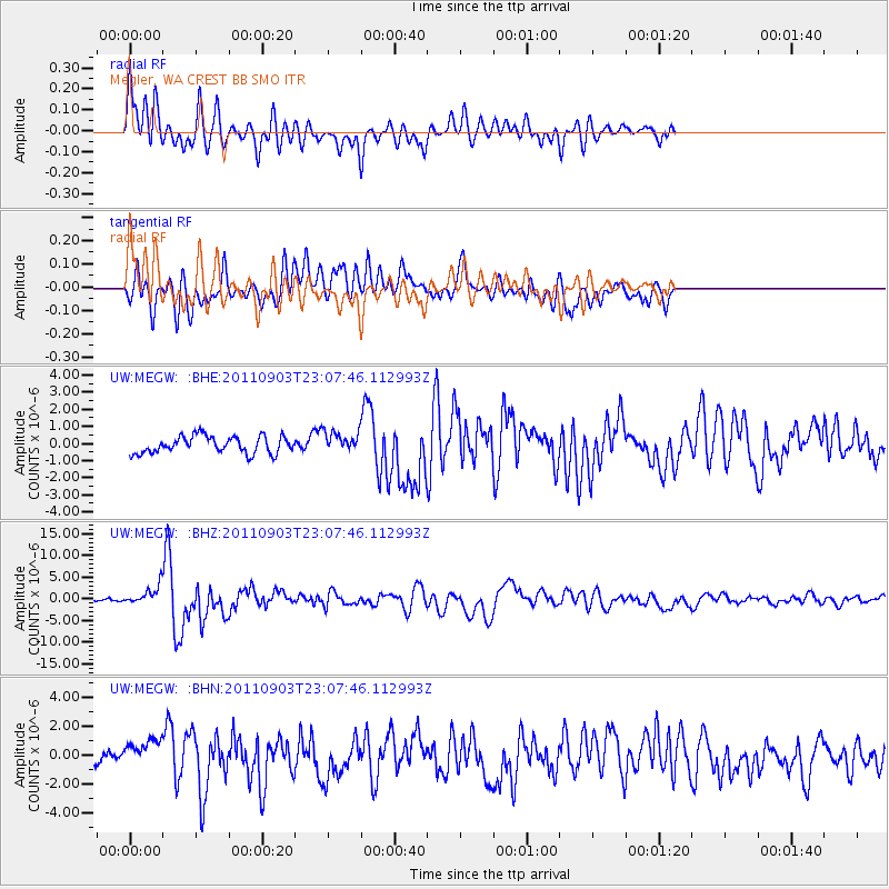
Signal To Noise
| Channel | StoN | STA | LTA |
| UW:MEGW: :BHZ:20110903T23:07:46.112993Z | 5.818142 | 2.139116E-6 | 3.676631E-7 |
| UW:MEGW: :BHN:20110903T23:07:46.112993Z | 1.9866593 | 1.0297058E-6 | 5.183102E-7 |
| UW:MEGW: :BHE:20110903T23:07:46.112993Z | 1.2229558 | 6.071316E-7 | 4.9644603E-7 |
| Arrivals |
| Ps | 3.9 SECOND |
| PpPs | 11 SECOND |
| PsPs/PpSs | 15 SECOND |


