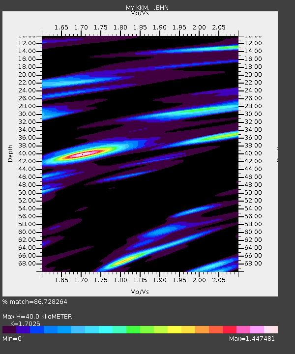
KKM Kota Kinabalu - Earthquake Result Viewer

Earthquake location: Vanuatu Islands
Earthquake latitude/longitude: -19.2/168.7
Earthquake time(UTC): 2011/09/04 (247) 21:44:18 GMT
Earthquake Depth: 37 km
Earthquake Magnitude: 5.7 MB, 5.4 MS, 5.9 MW, 5.9 MW
Earthquake Catalog/Contributor: WHDF/NEIC
Network: MY Malaysian National Seismic Network
Station: KKM Kota Kinabalu
Lat/Lon: 6.04 N/116.21 E
Elevation: 830 m
Distance: 57.4 deg
Az: 290.606 deg
Baz: 117.179 deg
Ray Param: 0.06342105
Estimated Moho Depth: 40.0 km
Estimated Crust Vp/Vs: 1.70
Assumed Crust Vp: 6.048 km/s
Estimated Crust Vs: 3.552 km/s
Estimated Crust Poisson's Ratio: 0.24
Radial Match: 86.728264 %
Radial Bump: 400
Transverse Match: 71.3711 %
Transverse Bump: 400
SOD ConfigId: 414626
Insert Time: 2012-01-20 10:25:35.678 +0000
GWidth: 2.5
Max Bumps: 400
Tol: 0.001

Signal To Noise

ChannelStoNSTALTA
MY:KKM: :BHZ:20110904T21:53:32.469973Z6.5032558.289515E-71.2746717E-7
MY:KKM: :BHN:20110904T21:53:32.469973Z1.7421193.4716624E-71.9927815E-7
MY:KKM: :BHE:20110904T21:53:32.469973Z2.19389343.1288582E-71.4261668E-7
Arrivals
Ps4.9 SECOND
PpPs17 SECOND
PsPs/PpSs22 SECOND