You are here: Home > Network List > UW - Pacific Northwest Regional Seismic Network Stations List
> Station LEBA Lebam, WA, USA > Earthquake Result Viewer
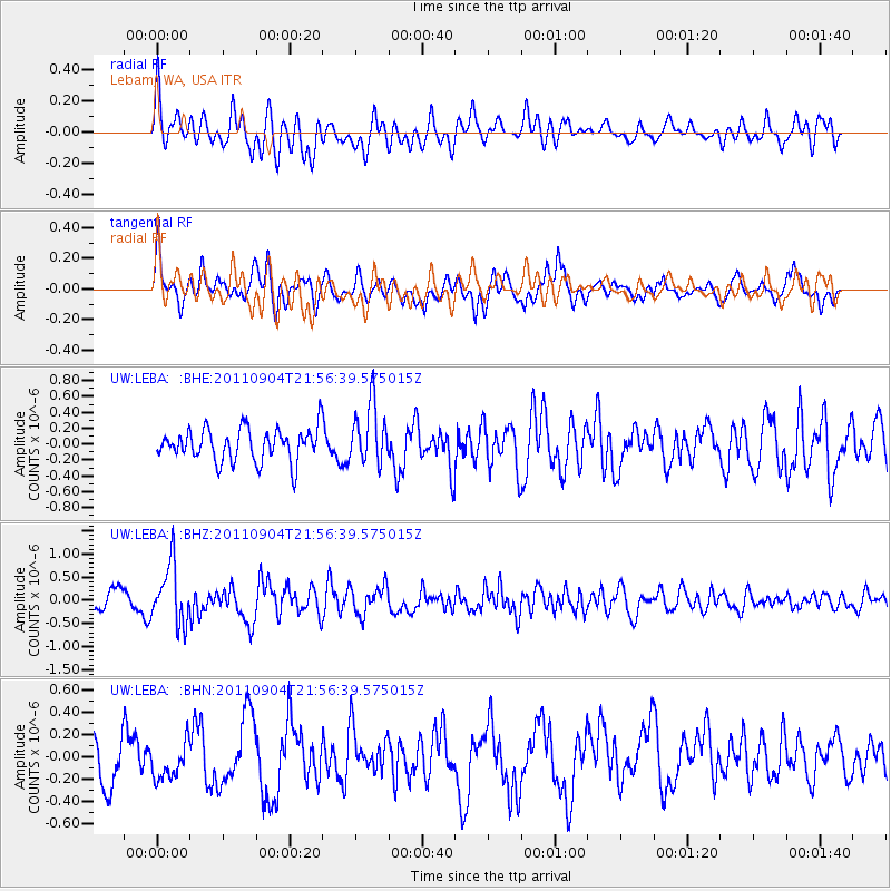
LEBA Lebam, WA, USA - Earthquake Result Viewer
*The percent match for this event was below the threshold and hence no stack was calculated.
| Earthquake location: |
Vanuatu Islands |
| Earthquake latitude/longitude: |
-19.2/168.7 |
| Earthquake time(UTC): |
2011/09/04 (247) 21:44:18 GMT |
| Earthquake Depth: |
37 km |
| Earthquake Magnitude: |
5.7 MB, 5.4 MS, 5.9 MW, 5.9 MW |
| Earthquake Catalog/Contributor: |
WHDF/NEIC |
|
| Network: |
UW Pacific Northwest Regional Seismic Network |
| Station: |
LEBA Lebam, WA, USA |
| Lat/Lon: |
46.55 N/123.56 W |
| Elevation: |
73 m |
|
| Distance: |
89.4 deg |
| Az: |
39.7 deg |
| Baz: |
241.013 deg |
| Ray Param: |
$rayparam |
*The percent match for this event was below the threshold and hence was not used in the summary stack. |
|
| Radial Match: |
66.47174 % |
| Radial Bump: |
400 |
| Transverse Match: |
76.324104 % |
| Transverse Bump: |
400 |
| SOD ConfigId: |
414626 |
| Insert Time: |
2012-01-20 10:32:03.761 +0000 |
| GWidth: |
2.5 |
| Max Bumps: |
400 |
| Tol: |
0.001 |
|
Signal To Noise
| Channel | StoN | STA | LTA |
| UW:LEBA: :BHZ:20110904T21:56:39.575015Z | 2.9498167 | 6.3371954E-7 | 2.1483353E-7 |
| UW:LEBA: :BHN:20110904T21:56:39.575015Z | 1.0146418 | 1.7051784E-7 | 1.680572E-7 |
| UW:LEBA: :BHE:20110904T21:56:39.575015Z | 1.8276722 | 3.7461072E-7 | 2.0496604E-7 |
| Arrivals |
| Ps | |
| PpPs | |
| PsPs/PpSs | |


