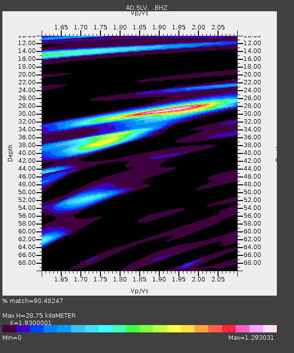
SLV Son La Vietnam - Earthquake Result Viewer

Earthquake location: Tonga Islands
Earthquake latitude/longitude: -15.3/-173.6
Earthquake time(UTC): 2011/09/05 (248) 09:52:01 GMT
Earthquake Depth: 37 km
Earthquake Magnitude: 6.2 MB, 6.2 MS, 6.3 MW, 6.2 MW
Earthquake Catalog/Contributor: WHDF/NEIC
Network: AD Asian Disaster Preparedness Center- Early Warning Center
Station: SLV Son La Vietnam
Lat/Lon: 21.33 N/103.90 E
Elevation: 50 m
Distance: 88.7 deg
Az: 292.405 deg
Baz: 106.869 deg
Ray Param: 0.04235454
Estimated Moho Depth: 28.75 km
Estimated Crust Vp/Vs: 1.93
Assumed Crust Vp: 6.35 km/s
Estimated Crust Vs: 3.29 km/s
Estimated Crust Poisson's Ratio: 0.32
Radial Match: 90.48247 %
Radial Bump: 400
Transverse Match: 85.58716 %
Transverse Bump: 400
SOD ConfigId: 414626
Insert Time: 2012-01-20 10:39:01.947 +0000
GWidth: 2.5
Max Bumps: 400
Tol: 0.001

Signal To Noise

ChannelStoNSTALTA
AD:SLV: :BHZ:20110905T10:04:19.36999Z3.99457433.237443E-78.104601E-8
AD:SLV: :BHN:20110905T10:04:19.36999Z1.18658964.561738E-83.844411E-8
AD:SLV: :BHE:20110905T10:04:19.36999Z2.60863161.4762266E-75.6590075E-8
Arrivals
Ps4.3 SECOND
PpPs13 SECOND
PsPs/PpSs17 SECOND