You are here: Home > Network List > CI - Caltech Regional Seismic Network Stations List
> Station MPM Manuel Prospect Mine, California, USA > Earthquake Result Viewer
MPM Manuel Prospect Mine, California, USA - Earthquake Result Viewer
| Earthquake location: |
Tonga Islands |
| Earthquake latitude/longitude: |
-15.3/-173.6 |
| Earthquake time(UTC): |
2011/09/05 (248) 09:52:01 GMT |
| Earthquake Depth: |
37 km |
| Earthquake Magnitude: |
6.2 MB, 6.2 MS, 6.3 MW, 6.2 MW |
| Earthquake Catalog/Contributor: |
WHDF/NEIC |
|
| Network: |
CI Caltech Regional Seismic Network |
| Station: |
MPM Manuel Prospect Mine, California, USA |
| Lat/Lon: |
36.06 N/117.49 W |
| Elevation: |
185 m |
|
| Distance: |
73.6 deg |
| Az: |
44.532 deg |
| Baz: |
236.639 deg |
| Ray Param: |
0.052830342 |
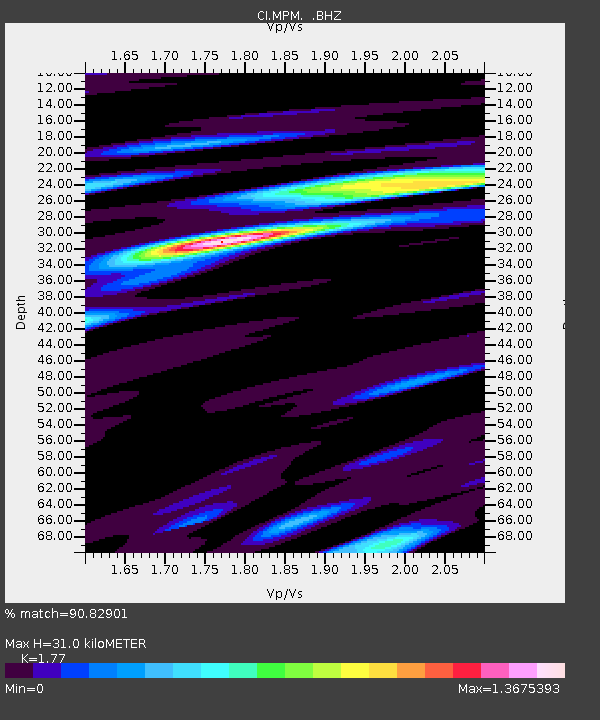
| Estimated Moho Depth: |
31.0 km |
| Estimated Crust Vp/Vs: |
1.77 |
| Assumed Crust Vp: |
6.279 km/s |
| Estimated Crust Vs: |
3.547 km/s |
| Estimated Crust Poisson's Ratio: |
0.27 |
|
| Radial Match: |
90.82901 % |
| Radial Bump: |
400 |
| Transverse Match: |
89.26924 % |
| Transverse Bump: |
400 |
| SOD ConfigId: |
414626 |
| Insert Time: |
2012-01-20 10:52:52.388 +0000 |
| GWidth: |
2.5 |
| Max Bumps: |
400 |
| Tol: |
0.001 |
|
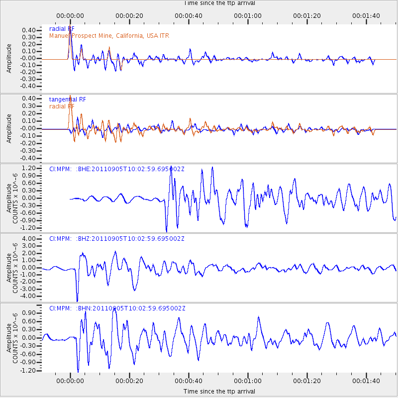
Signal To Noise
| Channel | StoN | STA | LTA |
| CI:MPM: :BHZ:20110905T10:02:59.695002Z | 16.2672 | 1.7352015E-6 | 1.0666873E-7 |
| CI:MPM: :BHN:20110905T10:02:59.695002Z | 6.163354 | 4.6242866E-7 | 7.502874E-8 |
| CI:MPM: :BHE:20110905T10:02:59.695002Z | 7.000456 | 5.7972545E-7 | 8.281253E-8 |
| Arrivals |
| Ps | 3.9 SECOND |
| PpPs | 13 SECOND |
| PsPs/PpSs | 17 SECOND |


