You are here: Home > Network List > CI - Caltech Regional Seismic Network Stations List
> Station SMM Simmler, CA, USA > Earthquake Result Viewer
SMM Simmler, CA, USA - Earthquake Result Viewer
*The percent match for this event was below the threshold and hence no stack was calculated.
| Earthquake location: |
Tonga Islands |
| Earthquake latitude/longitude: |
-15.3/-173.6 |
| Earthquake time(UTC): |
2011/09/05 (248) 09:52:01 GMT |
| Earthquake Depth: |
37 km |
| Earthquake Magnitude: |
6.2 MB, 6.2 MS, 6.3 MW, 6.2 MW |
| Earthquake Catalog/Contributor: |
WHDF/NEIC |
|
| Network: |
CI Caltech Regional Seismic Network |
| Station: |
SMM Simmler, CA, USA |
| Lat/Lon: |
35.31 N/120.00 W |
| Elevation: |
599 m |
|
| Distance: |
71.5 deg |
| Az: |
43.974 deg |
| Baz: |
235.016 deg |
| Ray Param: |
$rayparam |
*The percent match for this event was below the threshold and hence was not used in the summary stack. |
|
| Radial Match: |
70.923416 % |
| Radial Bump: |
400 |
| Transverse Match: |
82.14568 % |
| Transverse Bump: |
400 |
| SOD ConfigId: |
414626 |
| Insert Time: |
2012-01-20 10:54:19.750 +0000 |
| GWidth: |
2.5 |
| Max Bumps: |
400 |
| Tol: |
0.001 |
|
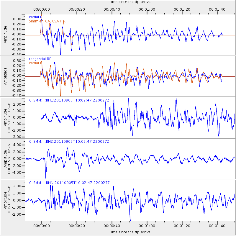
Signal To Noise
| Channel | StoN | STA | LTA |
| CI:SMM: :BHZ:20110905T10:02:47.220027Z | 7.2205205 | 1.9323288E-6 | 2.676163E-7 |
| CI:SMM: :BHN:20110905T10:02:47.220027Z | 2.337972 | 5.2979715E-7 | 2.2660545E-7 |
| CI:SMM: :BHE:20110905T10:02:47.220027Z | 1.636965 | 5.680496E-7 | 3.470139E-7 |
| Arrivals |
| Ps | |
| PpPs | |
| PsPs/PpSs | |


