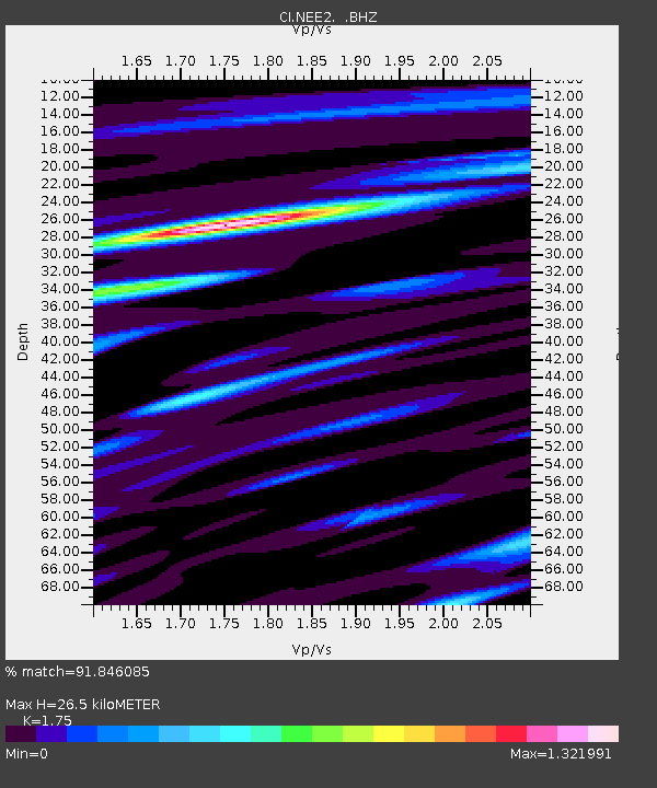
NEE2 Needles Airport - Earthquake Result Viewer
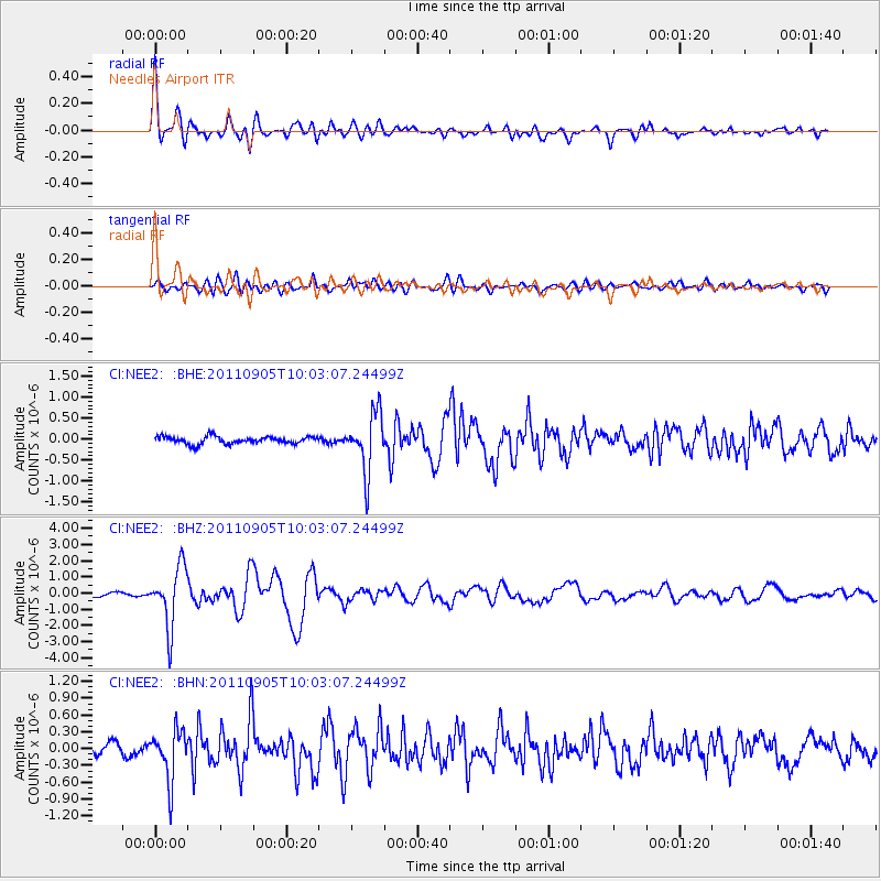
Earthquake location: Tonga Islands
Earthquake latitude/longitude: -15.3/-173.6
Earthquake time(UTC): 2011/09/05 (248) 09:52:01 GMT
Earthquake Depth: 37 km
Earthquake Magnitude: 6.2 MB, 6.2 MS, 6.3 MW, 6.2 MW
Earthquake Catalog/Contributor: WHDF/NEIC
Network: CI Caltech Regional Seismic Network
Station: NEE2 Needles Airport
Lat/Lon: 34.77 N/114.62 W
Elevation: 271 m
Distance: 74.9 deg
Az: 46.961 deg
Baz: 238.954 deg
Ray Param: 0.051959977
Estimated Moho Depth: 26.5 km
Estimated Crust Vp/Vs: 1.75
Assumed Crust Vp: 6.276 km/s
Estimated Crust Vs: 3.586 km/s
Estimated Crust Poisson's Ratio: 0.26
Radial Match: 91.846085 %
Radial Bump: 400
Transverse Match: 76.59904 %
Transverse Bump: 400
SOD ConfigId: 414626
Insert Time: 2012-01-20 10:56:36.383 +0000
GWidth: 2.5
Max Bumps: 400
Tol: 0.001

Signal To Noise

ChannelStoNSTALTA
CI:NEE2: :BHZ:20110905T10:03:07.24499Z13.60102751.8382384E-61.3515438E-7
CI:NEE2: :BHN:20110905T10:03:07.24499Z5.88412434.491688E-77.63357E-8
CI:NEE2: :BHE:20110905T10:03:07.24499Z7.83571436.886652E-78.788799E-8
Arrivals
Ps3.3 SECOND
PpPs11 SECOND
PsPs/PpSs15 SECOND