You are here: Home > Network List > G - GEOSCOPE Stations List
> Station INU Inuyama, Japan > Earthquake Result Viewer
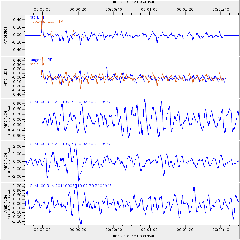
INU Inuyama, Japan - Earthquake Result Viewer
*The percent match for this event was below the threshold and hence no stack was calculated.
| Earthquake location: |
Tonga Islands |
| Earthquake latitude/longitude: |
-15.3/-173.6 |
| Earthquake time(UTC): |
2011/09/05 (248) 09:52:01 GMT |
| Earthquake Depth: |
37 km |
| Earthquake Magnitude: |
6.2 MB, 6.2 MS, 6.3 MW, 6.2 MW |
| Earthquake Catalog/Contributor: |
WHDF/NEIC |
|
| Network: |
G GEOSCOPE |
| Station: |
INU Inuyama, Japan |
| Lat/Lon: |
35.35 N/137.03 E |
| Elevation: |
132 m |
|
| Distance: |
68.7 deg |
| Az: |
318.273 deg |
| Baz: |
128.211 deg |
| Ray Param: |
$rayparam |
*The percent match for this event was below the threshold and hence was not used in the summary stack. |
|
| Radial Match: |
68.202324 % |
| Radial Bump: |
334 |
| Transverse Match: |
49.724953 % |
| Transverse Bump: |
359 |
| SOD ConfigId: |
414626 |
| Insert Time: |
2012-01-20 10:57:08.942 +0000 |
| GWidth: |
2.5 |
| Max Bumps: |
400 |
| Tol: |
0.001 |
|
Signal To Noise
| Channel | StoN | STA | LTA |
| G:INU:00:BHZ:20110905T10:02:30.210994Z | 3.6054583 | 8.953935E-7 | 2.4834387E-7 |
| G:INU:00:BHN:20110905T10:02:30.210994Z | 0.47690925 | 2.3374253E-7 | 4.9011953E-7 |
| G:INU:00:BHE:20110905T10:02:30.210994Z | 0.5927262 | 2.3496877E-7 | 3.9642043E-7 |
| Arrivals |
| Ps | |
| PpPs | |
| PsPs/PpSs | |


