You are here: Home > Network List > IU - Global Seismograph Network (GSN - IRIS/USGS) Stations List
> Station MIDW Midway Island, USA > Earthquake Result Viewer
MIDW Midway Island, USA - Earthquake Result Viewer
| Earthquake location: |
Tonga Islands |
| Earthquake latitude/longitude: |
-15.3/-173.6 |
| Earthquake time(UTC): |
2011/09/05 (248) 09:52:01 GMT |
| Earthquake Depth: |
37 km |
| Earthquake Magnitude: |
6.2 MB, 6.2 MS, 6.3 MW, 6.2 MW |
| Earthquake Catalog/Contributor: |
WHDF/NEIC |
|
| Network: |
IU Global Seismograph Network (GSN - IRIS/USGS) |
| Station: |
MIDW Midway Island, USA |
| Lat/Lon: |
28.22 N/177.37 W |
| Elevation: |
20 m |
|
| Distance: |
43.4 deg |
| Az: |
355.183 deg |
| Baz: |
174.732 deg |
| Ray Param: |
0.07249158 |
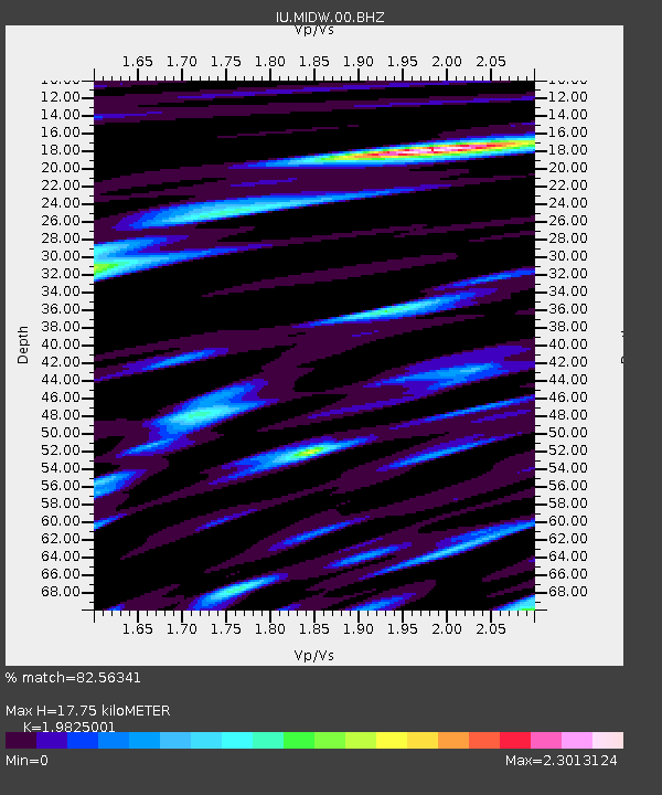
| Estimated Moho Depth: |
17.75 km |
| Estimated Crust Vp/Vs: |
1.98 |
| Assumed Crust Vp: |
4.24 km/s |
| Estimated Crust Vs: |
2.139 km/s |
| Estimated Crust Poisson's Ratio: |
0.33 |
|
| Radial Match: |
82.56341 % |
| Radial Bump: |
394 |
| Transverse Match: |
62.796364 % |
| Transverse Bump: |
400 |
| SOD ConfigId: |
414626 |
| Insert Time: |
2012-01-20 10:59:24.846 +0000 |
| GWidth: |
2.5 |
| Max Bumps: |
400 |
| Tol: |
0.001 |
|

Signal To Noise
| Channel | StoN | STA | LTA |
| IU:MIDW:00:BHZ:20110905T09:59:29.686Z | 7.603071 | 6.0701445E-6 | 7.9838065E-7 |
| IU:MIDW:00:BHN:20110905T09:59:29.686Z | 2.4084427 | 3.9183574E-6 | 1.6269258E-6 |
| IU:MIDW:00:BHE:20110905T09:59:29.686Z | 1.6743478 | 2.75333E-6 | 1.6444194E-6 |
| Arrivals |
| Ps | 4.2 SECOND |
| PpPs | 12 SECOND |
| PsPs/PpSs | 16 SECOND |


