You are here: Home > Network List > TA - USArray Transportable Network (new EarthScope stations) Stations List
> Station G05D Wamic, OR, USA > Earthquake Result Viewer
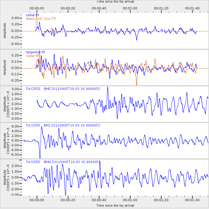
G05D Wamic, OR, USA - Earthquake Result Viewer
*The percent match for this event was below the threshold and hence no stack was calculated.
| Earthquake location: |
Tonga Islands |
| Earthquake latitude/longitude: |
-15.3/-173.6 |
| Earthquake time(UTC): |
2011/09/05 (248) 09:52:01 GMT |
| Earthquake Depth: |
37 km |
| Earthquake Magnitude: |
6.2 MB, 6.2 MS, 6.3 MW, 6.2 MW |
| Earthquake Catalog/Contributor: |
WHDF/NEIC |
|
| Network: |
TA USArray Transportable Network (new EarthScope stations) |
| Station: |
G05D Wamic, OR, USA |
| Lat/Lon: |
45.24 N/121.32 W |
| Elevation: |
592 m |
|
| Distance: |
76.6 deg |
| Az: |
35.073 deg |
| Baz: |
231.711 deg |
| Ray Param: |
$rayparam |
*The percent match for this event was below the threshold and hence was not used in the summary stack. |
|
| Radial Match: |
78.073425 % |
| Radial Bump: |
400 |
| Transverse Match: |
77.563995 % |
| Transverse Bump: |
400 |
| SOD ConfigId: |
414626 |
| Insert Time: |
2012-01-20 11:08:18.173 +0000 |
| GWidth: |
2.5 |
| Max Bumps: |
400 |
| Tol: |
0.001 |
|
Signal To Noise
| Channel | StoN | STA | LTA |
| TA:G05D: :BHZ:20110905T10:03:16.999995Z | 16.881632 | 3.2597384E-6 | 1.9309381E-7 |
| TA:G05D: :BHN:20110905T10:03:16.999995Z | 1.4756362 | 5.933832E-7 | 4.0212024E-7 |
| TA:G05D: :BHE:20110905T10:03:16.999995Z | 1.1865301 | 4.776862E-7 | 4.0259087E-7 |
| Arrivals |
| Ps | |
| PpPs | |
| PsPs/PpSs | |


