You are here: Home > Network List > TA - USArray Transportable Network (new EarthScope stations) Stations List
> Station U32A Winter Ranch, Mooreland, OK, USA > Earthquake Result Viewer
U32A Winter Ranch, Mooreland, OK, USA - Earthquake Result Viewer
| Earthquake location: |
Tonga Islands |
| Earthquake latitude/longitude: |
-15.3/-173.6 |
| Earthquake time(UTC): |
2011/09/05 (248) 09:52:01 GMT |
| Earthquake Depth: |
37 km |
| Earthquake Magnitude: |
6.2 MB, 6.2 MS, 6.3 MW, 6.2 MW |
| Earthquake Catalog/Contributor: |
WHDF/NEIC |
|
| Network: |
TA USArray Transportable Network (new EarthScope stations) |
| Station: |
U32A Winter Ranch, Mooreland, OK, USA |
| Lat/Lon: |
36.38 N/99.00 W |
| Elevation: |
525 m |
|
| Distance: |
87.0 deg |
| Az: |
51.182 deg |
| Baz: |
248.704 deg |
| Ray Param: |
0.04356466 |
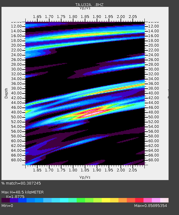
| Estimated Moho Depth: |
48.5 km |
| Estimated Crust Vp/Vs: |
1.88 |
| Assumed Crust Vp: |
6.426 km/s |
| Estimated Crust Vs: |
3.423 km/s |
| Estimated Crust Poisson's Ratio: |
0.30 |
|
| Radial Match: |
80.387245 % |
| Radial Bump: |
363 |
| Transverse Match: |
60.771496 % |
| Transverse Bump: |
397 |
| SOD ConfigId: |
414626 |
| Insert Time: |
2012-01-20 11:08:29.856 +0000 |
| GWidth: |
2.5 |
| Max Bumps: |
400 |
| Tol: |
0.001 |
|

Signal To Noise
| Channel | StoN | STA | LTA |
| TA:U32A: :BHZ:20110905T10:04:11.52502Z | 6.6699896 | 1.0599559E-6 | 1.5891418E-7 |
| TA:U32A: :BHN:20110905T10:04:11.52502Z | 0.96221316 | 1.8807434E-7 | 1.9546015E-7 |
| TA:U32A: :BHE:20110905T10:04:11.52502Z | 1.6661699 | 4.1347351E-7 | 2.4815807E-7 |
| Arrivals |
| Ps | 6.8 SECOND |
| PpPs | 21 SECOND |
| PsPs/PpSs | 28 SECOND |


