You are here: Home > Network List > TA - USArray Transportable Network (new EarthScope stations) Stations List
> Station 734A La Parita Creek, Jourdanton, TX, USA > Earthquake Result Viewer
734A La Parita Creek, Jourdanton, TX, USA - Earthquake Result Viewer
| Earthquake location: |
Tonga Islands |
| Earthquake latitude/longitude: |
-15.3/-173.6 |
| Earthquake time(UTC): |
2011/09/05 (248) 09:52:01 GMT |
| Earthquake Depth: |
37 km |
| Earthquake Magnitude: |
6.2 MB, 6.2 MS, 6.3 MW, 6.2 MW |
| Earthquake Catalog/Contributor: |
WHDF/NEIC |
|
| Network: |
TA USArray Transportable Network (new EarthScope stations) |
| Station: |
734A La Parita Creek, Jourdanton, TX, USA |
| Lat/Lon: |
28.85 N/98.56 W |
| Elevation: |
121 m |
|
| Distance: |
84.7 deg |
| Az: |
58.35 deg |
| Baz: |
249.46 deg |
| Ray Param: |
0.045242377 |
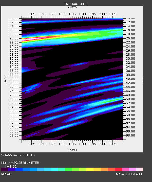
| Estimated Moho Depth: |
20.25 km |
| Estimated Crust Vp/Vs: |
1.62 |
| Assumed Crust Vp: |
6.347 km/s |
| Estimated Crust Vs: |
3.918 km/s |
| Estimated Crust Poisson's Ratio: |
0.19 |
|
| Radial Match: |
82.681816 % |
| Radial Bump: |
400 |
| Transverse Match: |
68.504135 % |
| Transverse Bump: |
400 |
| SOD ConfigId: |
414626 |
| Insert Time: |
2012-01-20 11:11:29.128 +0000 |
| GWidth: |
2.5 |
| Max Bumps: |
400 |
| Tol: |
0.001 |
|

Signal To Noise
| Channel | StoN | STA | LTA |
| TA:734A: :BHZ:20110905T10:04:00.02502Z | 6.7365427 | 1.5978907E-6 | 2.3719744E-7 |
| TA:734A: :BHN:20110905T10:04:00.02502Z | 0.9405199 | 2.794098E-7 | 2.9708016E-7 |
| TA:734A: :BHE:20110905T10:04:00.02502Z | 1.3692361 | 3.843985E-7 | 2.8073936E-7 |
| Arrivals |
| Ps | 2.0 SECOND |
| PpPs | 8.1 SECOND |
| PsPs/PpSs | 10 SECOND |


