You are here: Home > Network List > TA - USArray Transportable Network (new EarthScope stations) Stations List
> Station 536A Bastrop, TX, USA > Earthquake Result Viewer
536A Bastrop, TX, USA - Earthquake Result Viewer

| Earthquake location: |
Tonga Islands |
| Earthquake latitude/longitude: |
-15.3/-173.6 |
| Earthquake time(UTC): |
2011/09/05 (248) 09:52:01 GMT |
| Earthquake Depth: |
37 km |
| Earthquake Magnitude: |
6.2 MB, 6.2 MS, 6.3 MW, 6.2 MW |
| Earthquake Catalog/Contributor: |
WHDF/NEIC |
|
| Network: |
TA USArray Transportable Network (new EarthScope stations) |
| Station: |
536A Bastrop, TX, USA |
| Lat/Lon: |
30.08 N/97.07 W |
| Elevation: |
115 m |
|
| Distance: |
86.3 deg |
| Az: |
57.649 deg |
| Baz: |
250.135 deg |
| Ray Param: |
0.044068348 |
| Estimated Moho Depth: |
10.75 km |
| Estimated Crust Vp/Vs: |
1.60 |
| Assumed Crust Vp: |
6.347 km/s |
| Estimated Crust Vs: |
3.967 km/s |
| Estimated Crust Poisson's Ratio: |
0.18 |
|
| Radial Match: |
83.73141 % |
| Radial Bump: |
400 |
| Transverse Match: |
76.45535 % |
| Transverse Bump: |
400 |
| SOD ConfigId: |
414626 |
| Insert Time: |
2012-01-20 11:13:27.739 +0000 |
| GWidth: |
2.5 |
| Max Bumps: |
400 |
| Tol: |
0.001 |
|
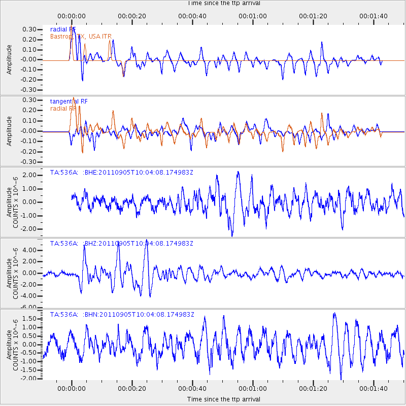
Signal To Noise
| Channel | StoN | STA | LTA |
| TA:536A: :BHZ:20110905T10:04:08.174983Z | 7.6771874 | 1.8835207E-6 | 2.4533995E-7 |
| TA:536A: :BHN:20110905T10:04:08.174983Z | 1.6143346 | 6.0995023E-7 | 3.7783386E-7 |
| TA:536A: :BHE:20110905T10:04:08.174983Z | 0.90198195 | 3.5795054E-7 | 3.968489E-7 |
| Arrivals |
| Ps | 1.0 SECOND |
| PpPs | 4.3 SECOND |
| PsPs/PpSs | 5.3 SECOND |


