You are here: Home > Network List > TA - USArray Transportable Network (new EarthScope stations) Stations List
> Station W36A Wetumka, OK, USA > Earthquake Result Viewer
W36A Wetumka, OK, USA - Earthquake Result Viewer
| Earthquake location: |
Tonga Islands |
| Earthquake latitude/longitude: |
-15.3/-173.6 |
| Earthquake time(UTC): |
2011/09/05 (248) 09:52:01 GMT |
| Earthquake Depth: |
37 km |
| Earthquake Magnitude: |
6.2 MB, 6.2 MS, 6.3 MW, 6.2 MW |
| Earthquake Catalog/Contributor: |
WHDF/NEIC |
|
| Network: |
TA USArray Transportable Network (new EarthScope stations) |
| Station: |
W36A Wetumka, OK, USA |
| Lat/Lon: |
35.14 N/96.23 W |
| Elevation: |
251 m |
|
| Distance: |
88.7 deg |
| Az: |
53.131 deg |
| Baz: |
250.391 deg |
| Ray Param: |
0.042327784 |
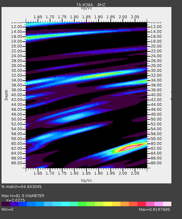
| Estimated Moho Depth: |
61.5 km |
| Estimated Crust Vp/Vs: |
2.03 |
| Assumed Crust Vp: |
6.426 km/s |
| Estimated Crust Vs: |
3.169 km/s |
| Estimated Crust Poisson's Ratio: |
0.34 |
|
| Radial Match: |
84.643845 % |
| Radial Bump: |
394 |
| Transverse Match: |
68.71633 % |
| Transverse Bump: |
373 |
| SOD ConfigId: |
414626 |
| Insert Time: |
2012-01-20 11:16:37.351 +0000 |
| GWidth: |
2.5 |
| Max Bumps: |
400 |
| Tol: |
0.001 |
|
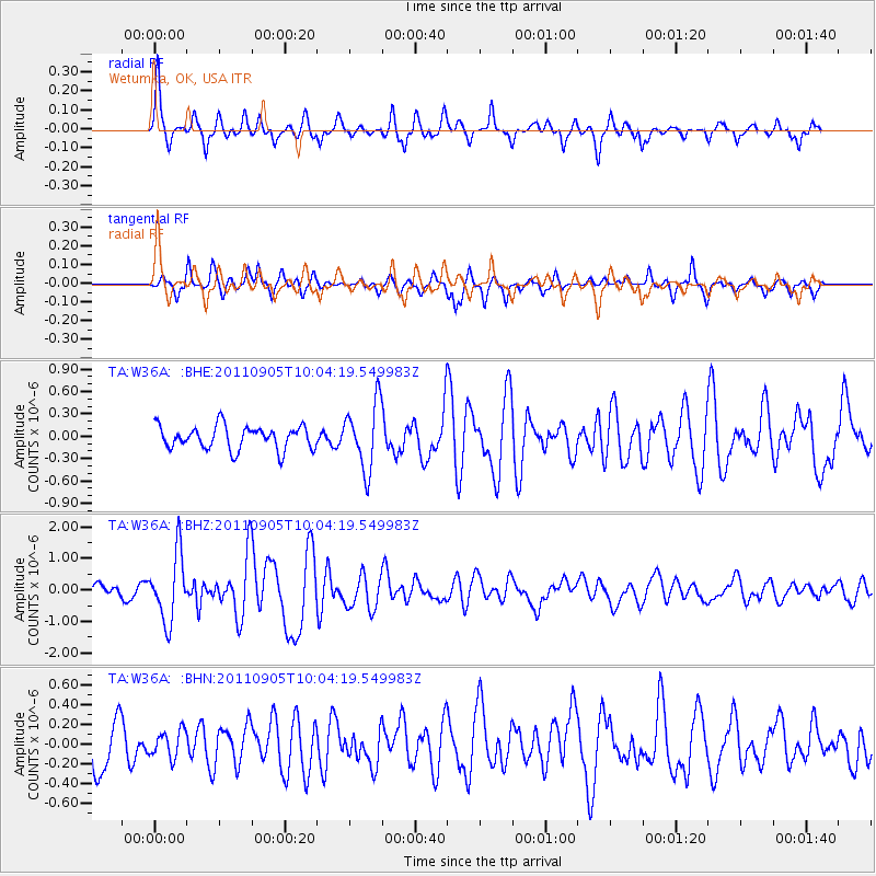
Signal To Noise
| Channel | StoN | STA | LTA |
| TA:W36A: :BHZ:20110905T10:04:19.549983Z | 7.668226 | 1.060019E-6 | 1.3823524E-7 |
| TA:W36A: :BHN:20110905T10:04:19.549983Z | 0.6044786 | 1.3609741E-7 | 2.2514844E-7 |
| TA:W36A: :BHE:20110905T10:04:19.549983Z | 2.8102448 | 4.4048684E-7 | 1.5674324E-7 |
| Arrivals |
| Ps | 10 SECOND |
| PpPs | 28 SECOND |
| PsPs/PpSs | 38 SECOND |


