You are here: Home > Network List > TA - USArray Transportable Network (new EarthScope stations) Stations List
> Station Y37A Hugo, OK, USA > Earthquake Result Viewer
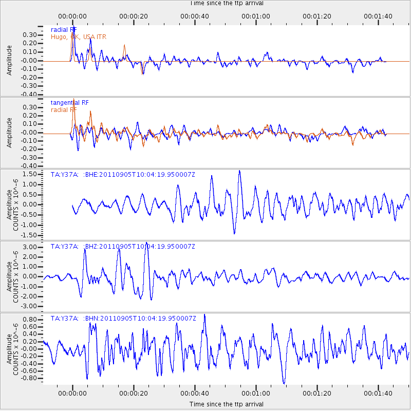
Y37A Hugo, OK, USA - Earthquake Result Viewer
*The percent match for this event was below the threshold and hence no stack was calculated.
| Earthquake location: |
Tonga Islands |
| Earthquake latitude/longitude: |
-15.3/-173.6 |
| Earthquake time(UTC): |
2011/09/05 (248) 09:52:01 GMT |
| Earthquake Depth: |
37 km |
| Earthquake Magnitude: |
6.2 MB, 6.2 MS, 6.3 MW, 6.2 MW |
| Earthquake Catalog/Contributor: |
WHDF/NEIC |
|
| Network: |
TA USArray Transportable Network (new EarthScope stations) |
| Station: |
Y37A Hugo, OK, USA |
| Lat/Lon: |
33.98 N/95.62 W |
| Elevation: |
165 m |
|
| Distance: |
88.8 deg |
| Az: |
54.39 deg |
| Baz: |
250.76 deg |
| Ray Param: |
$rayparam |
*The percent match for this event was below the threshold and hence was not used in the summary stack. |
|
| Radial Match: |
78.17096 % |
| Radial Bump: |
400 |
| Transverse Match: |
72.75938 % |
| Transverse Bump: |
400 |
| SOD ConfigId: |
414626 |
| Insert Time: |
2012-01-20 11:18:07.893 +0000 |
| GWidth: |
2.5 |
| Max Bumps: |
400 |
| Tol: |
0.001 |
|
Signal To Noise
| Channel | StoN | STA | LTA |
| TA:Y37A: :BHZ:20110905T10:04:19.950007Z | 6.046239 | 1.1985483E-6 | 1.9823038E-7 |
| TA:Y37A: :BHN:20110905T10:04:19.950007Z | 1.5346597 | 2.291898E-7 | 1.4934243E-7 |
| TA:Y37A: :BHE:20110905T10:04:19.950007Z | 2.0047772 | 4.883009E-7 | 2.4356868E-7 |
| Arrivals |
| Ps | |
| PpPs | |
| PsPs/PpSs | |


