You are here: Home > Network List > TA - USArray Transportable Network (new EarthScope stations) Stations List
> Station Y38A Idabel, OK, USA > Earthquake Result Viewer
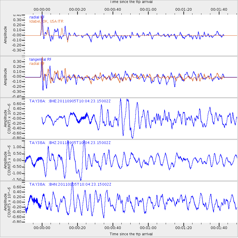
Y38A Idabel, OK, USA - Earthquake Result Viewer
*The percent match for this event was below the threshold and hence no stack was calculated.
| Earthquake location: |
Tonga Islands |
| Earthquake latitude/longitude: |
-15.3/-173.6 |
| Earthquake time(UTC): |
2011/09/05 (248) 09:52:01 GMT |
| Earthquake Depth: |
37 km |
| Earthquake Magnitude: |
6.2 MB, 6.2 MS, 6.3 MW, 6.2 MW |
| Earthquake Catalog/Contributor: |
WHDF/NEIC |
|
| Network: |
TA USArray Transportable Network (new EarthScope stations) |
| Station: |
Y38A Idabel, OK, USA |
| Lat/Lon: |
33.93 N/94.73 W |
| Elevation: |
118 m |
|
| Distance: |
89.5 deg |
| Az: |
54.679 deg |
| Baz: |
251.259 deg |
| Ray Param: |
$rayparam |
*The percent match for this event was below the threshold and hence was not used in the summary stack. |
|
| Radial Match: |
66.94623 % |
| Radial Bump: |
400 |
| Transverse Match: |
68.66634 % |
| Transverse Bump: |
400 |
| SOD ConfigId: |
414626 |
| Insert Time: |
2012-01-20 11:18:08.277 +0000 |
| GWidth: |
2.5 |
| Max Bumps: |
400 |
| Tol: |
0.001 |
|
Signal To Noise
| Channel | StoN | STA | LTA |
| TA:Y38A: :BHZ:20110905T10:04:23.15002Z | 2.4893367 | 5.994613E-7 | 2.408117E-7 |
| TA:Y38A: :BHN:20110905T10:04:23.15002Z | 0.75916857 | 1.9420628E-7 | 2.5581443E-7 |
| TA:Y38A: :BHE:20110905T10:04:23.15002Z | 2.1552362 | 2.8567547E-7 | 1.3254949E-7 |
| Arrivals |
| Ps | |
| PpPs | |
| PsPs/PpSs | |


