You are here: Home > Network List > TA - USArray Transportable Network (new EarthScope stations) Stations List
> Station T34A McClaskey Farms, Geuda Springs, KS, USA > Earthquake Result Viewer
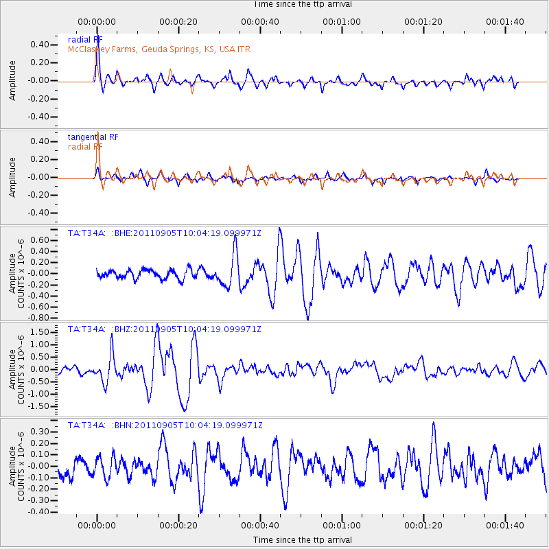
T34A McClaskey Farms, Geuda Springs, KS, USA - Earthquake Result Viewer
*The percent match for this event was below the threshold and hence no stack was calculated.
| Earthquake location: |
Tonga Islands |
| Earthquake latitude/longitude: |
-15.3/-173.6 |
| Earthquake time(UTC): |
2011/09/05 (248) 09:52:01 GMT |
| Earthquake Depth: |
37 km |
| Earthquake Magnitude: |
6.2 MB, 6.2 MS, 6.3 MW, 6.2 MW |
| Earthquake Catalog/Contributor: |
WHDF/NEIC |
|
| Network: |
TA USArray Transportable Network (new EarthScope stations) |
| Station: |
T34A McClaskey Farms, Geuda Springs, KS, USA |
| Lat/Lon: |
37.02 N/97.19 W |
| Elevation: |
361 m |
|
| Distance: |
88.6 deg |
| Az: |
51.099 deg |
| Baz: |
249.78 deg |
| Ray Param: |
$rayparam |
*The percent match for this event was below the threshold and hence was not used in the summary stack. |
|
| Radial Match: |
75.71637 % |
| Radial Bump: |
400 |
| Transverse Match: |
61.853634 % |
| Transverse Bump: |
387 |
| SOD ConfigId: |
414626 |
| Insert Time: |
2012-01-20 11:18:25.295 +0000 |
| GWidth: |
2.5 |
| Max Bumps: |
400 |
| Tol: |
0.001 |
|
Signal To Noise
| Channel | StoN | STA | LTA |
| TA:T34A: :BHZ:20110905T10:04:19.099971Z | 4.998672 | 5.7317635E-7 | 1.14665724E-7 |
| TA:T34A: :BHN:20110905T10:04:19.099971Z | 0.659822 | 9.0728484E-8 | 1.3750449E-7 |
| TA:T34A: :BHE:20110905T10:04:19.099971Z | 3.8466861 | 2.9569472E-7 | 7.686999E-8 |
| Arrivals |
| Ps | |
| PpPs | |
| PsPs/PpSs | |


