You are here: Home > Network List > TA - USArray Transportable Network (new EarthScope stations) Stations List
> Station V37A Hulbert, OK, USA > Earthquake Result Viewer
V37A Hulbert, OK, USA - Earthquake Result Viewer
| Earthquake location: |
Tonga Islands |
| Earthquake latitude/longitude: |
-15.3/-173.6 |
| Earthquake time(UTC): |
2011/09/05 (248) 09:52:01 GMT |
| Earthquake Depth: |
37 km |
| Earthquake Magnitude: |
6.2 MB, 6.2 MS, 6.3 MW, 6.2 MW |
| Earthquake Catalog/Contributor: |
WHDF/NEIC |
|
| Network: |
TA USArray Transportable Network (new EarthScope stations) |
| Station: |
V37A Hulbert, OK, USA |
| Lat/Lon: |
35.88 N/95.14 W |
| Elevation: |
219 m |
|
| Distance: |
89.8 deg |
| Az: |
52.724 deg |
| Baz: |
251.013 deg |
| Ray Param: |
0.041714255 |
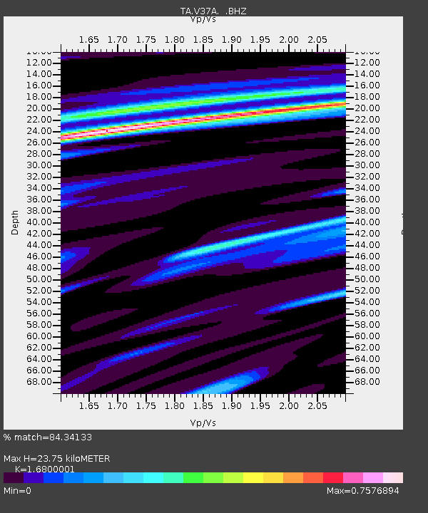
| Estimated Moho Depth: |
23.75 km |
| Estimated Crust Vp/Vs: |
1.68 |
| Assumed Crust Vp: |
6.498 km/s |
| Estimated Crust Vs: |
3.868 km/s |
| Estimated Crust Poisson's Ratio: |
0.23 |
|
| Radial Match: |
84.34133 % |
| Radial Bump: |
287 |
| Transverse Match: |
58.77826 % |
| Transverse Bump: |
358 |
| SOD ConfigId: |
414626 |
| Insert Time: |
2012-01-20 11:21:18.046 +0000 |
| GWidth: |
2.5 |
| Max Bumps: |
400 |
| Tol: |
0.001 |
|
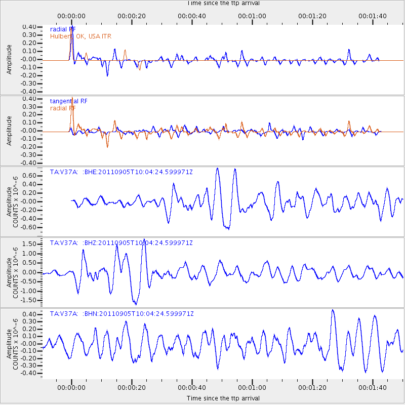
Signal To Noise
| Channel | StoN | STA | LTA |
| TA:V37A: :BHZ:20110905T10:04:24.599971Z | 5.533178 | 6.330773E-7 | 1.14414775E-7 |
| TA:V37A: :BHN:20110905T10:04:24.599971Z | 1.2732099 | 1.1929141E-7 | 9.369343E-8 |
| TA:V37A: :BHE:20110905T10:04:24.599971Z | 3.8977141 | 2.5826697E-7 | 6.626114E-8 |
| Arrivals |
| Ps | 2.5 SECOND |
| PpPs | 9.6 SECOND |
| PsPs/PpSs | 12 SECOND |


