You are here: Home > Network List > TA - USArray Transportable Network (new EarthScope stations) Stations List
> Station U35A Pawnee, OK, USA > Earthquake Result Viewer
U35A Pawnee, OK, USA - Earthquake Result Viewer
| Earthquake location: |
Tonga Islands |
| Earthquake latitude/longitude: |
-15.3/-173.6 |
| Earthquake time(UTC): |
2011/09/05 (248) 09:52:01 GMT |
| Earthquake Depth: |
37 km |
| Earthquake Magnitude: |
6.2 MB, 6.2 MS, 6.3 MW, 6.2 MW |
| Earthquake Catalog/Contributor: |
WHDF/NEIC |
|
| Network: |
TA USArray Transportable Network (new EarthScope stations) |
| Station: |
U35A Pawnee, OK, USA |
| Lat/Lon: |
36.37 N/96.73 W |
| Elevation: |
303 m |
|
| Distance: |
88.7 deg |
| Az: |
51.836 deg |
| Baz: |
250.068 deg |
| Ray Param: |
0.042306244 |
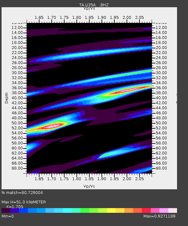
| Estimated Moho Depth: |
51.0 km |
| Estimated Crust Vp/Vs: |
1.71 |
| Assumed Crust Vp: |
6.483 km/s |
| Estimated Crust Vs: |
3.802 km/s |
| Estimated Crust Poisson's Ratio: |
0.24 |
|
| Radial Match: |
80.729004 % |
| Radial Bump: |
333 |
| Transverse Match: |
57.110126 % |
| Transverse Bump: |
341 |
| SOD ConfigId: |
414626 |
| Insert Time: |
2012-01-20 11:22:16.680 +0000 |
| GWidth: |
2.5 |
| Max Bumps: |
400 |
| Tol: |
0.001 |
|
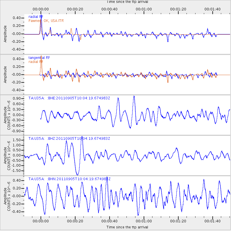
Signal To Noise
| Channel | StoN | STA | LTA |
| TA:U35A: :BHZ:20110905T10:04:19.674983Z | 4.093801 | 6.0444876E-7 | 1.4764976E-7 |
| TA:U35A: :BHN:20110905T10:04:19.674983Z | 1.5851405 | 2.589781E-7 | 1.6337863E-7 |
| TA:U35A: :BHE:20110905T10:04:19.674983Z | 1.6028991 | 2.6160984E-7 | 1.6321043E-7 |
| Arrivals |
| Ps | 5.7 SECOND |
| PpPs | 21 SECOND |
| PsPs/PpSs | 26 SECOND |


