You are here: Home > Network List > TA - USArray Transportable Network (new EarthScope stations) Stations List
> Station A04D Lummi Island, WA, USA > Earthquake Result Viewer
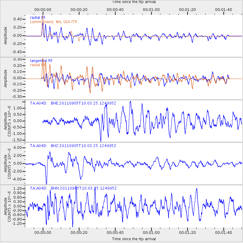
A04D Lummi Island, WA, USA - Earthquake Result Viewer
*The percent match for this event was below the threshold and hence no stack was calculated.
| Earthquake location: |
Tonga Islands |
| Earthquake latitude/longitude: |
-15.3/-173.6 |
| Earthquake time(UTC): |
2011/09/05 (248) 09:52:01 GMT |
| Earthquake Depth: |
37 km |
| Earthquake Magnitude: |
6.2 MB, 6.2 MS, 6.3 MW, 6.2 MW |
| Earthquake Catalog/Contributor: |
WHDF/NEIC |
|
| Network: |
TA USArray Transportable Network (new EarthScope stations) |
| Station: |
A04D Lummi Island, WA, USA |
| Lat/Lon: |
48.72 N/122.71 W |
| Elevation: |
13 m |
|
| Distance: |
78.1 deg |
| Az: |
31.692 deg |
| Baz: |
229.957 deg |
| Ray Param: |
$rayparam |
*The percent match for this event was below the threshold and hence was not used in the summary stack. |
|
| Radial Match: |
78.888016 % |
| Radial Bump: |
400 |
| Transverse Match: |
78.23834 % |
| Transverse Bump: |
400 |
| SOD ConfigId: |
414626 |
| Insert Time: |
2012-01-20 11:26:01.447 +0000 |
| GWidth: |
2.5 |
| Max Bumps: |
400 |
| Tol: |
0.001 |
|
Signal To Noise
| Channel | StoN | STA | LTA |
| TA:A04D: :BHZ:20110905T10:03:25.124995Z | 8.500203 | 2.0338944E-6 | 2.3927598E-7 |
| TA:A04D: :BHN:20110905T10:03:25.124995Z | 2.564647 | 5.3553356E-7 | 2.0881376E-7 |
| TA:A04D: :BHE:20110905T10:03:25.124995Z | 3.9419823 | 7.0186394E-7 | 1.7804848E-7 |
| Arrivals |
| Ps | |
| PpPs | |
| PsPs/PpSs | |


