You are here: Home > Network List > TA - USArray Transportable Network (new EarthScope stations) Stations List
> Station F33A 5 Mile Ranch, Herman, MN, USA > Earthquake Result Viewer
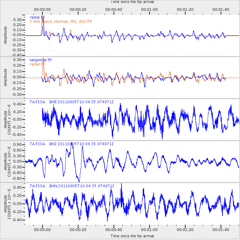
F33A 5 Mile Ranch, Herman, MN, USA - Earthquake Result Viewer
*The percent match for this event was below the threshold and hence no stack was calculated.
| Earthquake location: |
Tonga Islands |
| Earthquake latitude/longitude: |
-15.3/-173.6 |
| Earthquake time(UTC): |
2011/09/05 (248) 09:52:01 GMT |
| Earthquake Depth: |
37 km |
| Earthquake Magnitude: |
6.2 MB, 6.2 MS, 6.3 MW, 6.2 MW |
| Earthquake Catalog/Contributor: |
WHDF/NEIC |
|
| Network: |
TA USArray Transportable Network (new EarthScope stations) |
| Station: |
F33A 5 Mile Ranch, Herman, MN, USA |
| Lat/Lon: |
45.84 N/96.29 W |
| Elevation: |
313 m |
|
| Distance: |
92.3 deg |
| Az: |
43.045 deg |
| Baz: |
250.434 deg |
| Ray Param: |
$rayparam |
*The percent match for this event was below the threshold and hence was not used in the summary stack. |
|
| Radial Match: |
60.090027 % |
| Radial Bump: |
400 |
| Transverse Match: |
46.39611 % |
| Transverse Bump: |
400 |
| SOD ConfigId: |
414626 |
| Insert Time: |
2012-01-20 11:26:39.519 +0000 |
| GWidth: |
2.5 |
| Max Bumps: |
400 |
| Tol: |
0.001 |
|
Signal To Noise
| Channel | StoN | STA | LTA |
| TA:F33A: :BHZ:20110905T10:04:35.974971Z | 2.4388382 | 3.468096E-7 | 1.422028E-7 |
| TA:F33A: :BHN:20110905T10:04:35.974971Z | 0.7747522 | 1.2336136E-7 | 1.5922687E-7 |
| TA:F33A: :BHE:20110905T10:04:35.974971Z | 0.70159507 | 9.637043E-8 | 1.3735905E-7 |
| Arrivals |
| Ps | |
| PpPs | |
| PsPs/PpSs | |


