You are here: Home > Network List > TA - USArray Transportable Network (new EarthScope stations) Stations List
> Station E36A McGregor, MN, USA > Earthquake Result Viewer
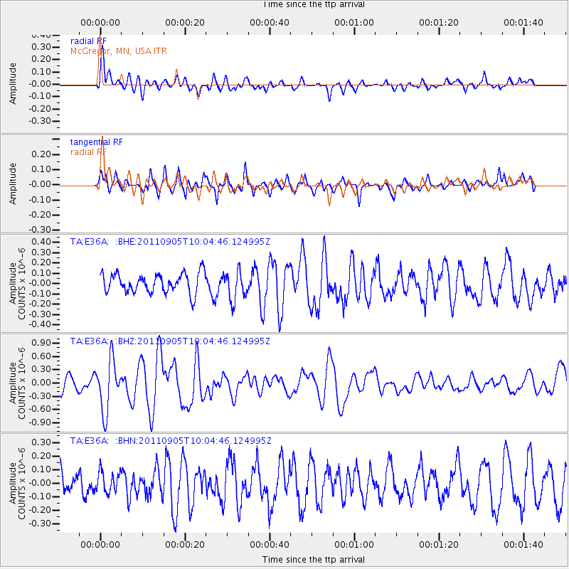
E36A McGregor, MN, USA - Earthquake Result Viewer
*The percent match for this event was below the threshold and hence no stack was calculated.
| Earthquake location: |
Tonga Islands |
| Earthquake latitude/longitude: |
-15.3/-173.6 |
| Earthquake time(UTC): |
2011/09/05 (248) 09:52:01 GMT |
| Earthquake Depth: |
37 km |
| Earthquake Magnitude: |
6.2 MB, 6.2 MS, 6.3 MW, 6.2 MW |
| Earthquake Catalog/Contributor: |
WHDF/NEIC |
|
| Network: |
TA USArray Transportable Network (new EarthScope stations) |
| Station: |
E36A McGregor, MN, USA |
| Lat/Lon: |
46.52 N/93.26 W |
| Elevation: |
393 m |
|
| Distance: |
94.5 deg |
| Az: |
43.071 deg |
| Baz: |
252.617 deg |
| Ray Param: |
$rayparam |
*The percent match for this event was below the threshold and hence was not used in the summary stack. |
|
| Radial Match: |
66.46721 % |
| Radial Bump: |
400 |
| Transverse Match: |
62.904217 % |
| Transverse Bump: |
400 |
| SOD ConfigId: |
414626 |
| Insert Time: |
2012-01-20 11:31:17.391 +0000 |
| GWidth: |
2.5 |
| Max Bumps: |
400 |
| Tol: |
0.001 |
|
Signal To Noise
| Channel | StoN | STA | LTA |
| TA:E36A: :BHZ:20110905T10:04:46.124995Z | 2.7998447 | 5.8672583E-7 | 2.0955656E-7 |
| TA:E36A: :BHN:20110905T10:04:46.124995Z | 0.5480672 | 7.908068E-8 | 1.4429011E-7 |
| TA:E36A: :BHE:20110905T10:04:46.124995Z | 1.513092 | 1.4172075E-7 | 9.3663004E-8 |
| Arrivals |
| Ps | |
| PpPs | |
| PsPs/PpSs | |


