You are here: Home > Network List > TA - USArray Transportable Network (new EarthScope stations) Stations List
> Station O38A Galt, MO, USA > Earthquake Result Viewer
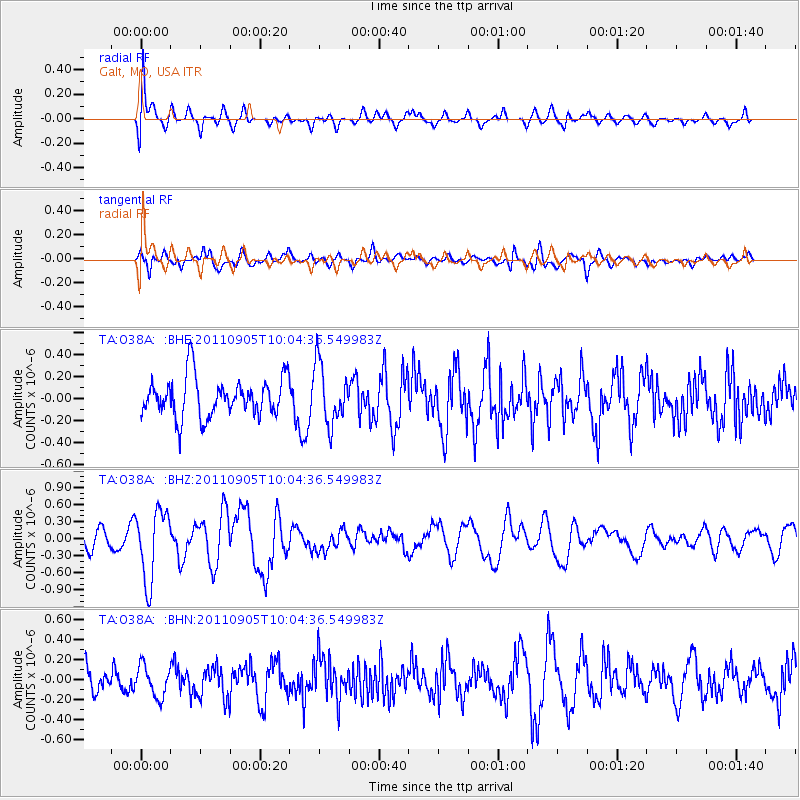
O38A Galt, MO, USA - Earthquake Result Viewer
*The percent match for this event was below the threshold and hence no stack was calculated.
| Earthquake location: |
Tonga Islands |
| Earthquake latitude/longitude: |
-15.3/-173.6 |
| Earthquake time(UTC): |
2011/09/05 (248) 09:52:01 GMT |
| Earthquake Depth: |
37 km |
| Earthquake Magnitude: |
6.2 MB, 6.2 MS, 6.3 MW, 6.2 MW |
| Earthquake Catalog/Contributor: |
WHDF/NEIC |
|
| Network: |
TA USArray Transportable Network (new EarthScope stations) |
| Station: |
O38A Galt, MO, USA |
| Lat/Lon: |
40.12 N/93.47 W |
| Elevation: |
266 m |
|
| Distance: |
92.4 deg |
| Az: |
49.126 deg |
| Baz: |
252.105 deg |
| Ray Param: |
$rayparam |
*The percent match for this event was below the threshold and hence was not used in the summary stack. |
|
| Radial Match: |
65.340385 % |
| Radial Bump: |
400 |
| Transverse Match: |
68.238396 % |
| Transverse Bump: |
400 |
| SOD ConfigId: |
414626 |
| Insert Time: |
2012-01-20 11:33:08.174 +0000 |
| GWidth: |
2.5 |
| Max Bumps: |
400 |
| Tol: |
0.001 |
|
Signal To Noise
| Channel | StoN | STA | LTA |
| TA:O38A: :BHZ:20110905T10:04:36.549983Z | 2.945448 | 6.163367E-7 | 2.0925057E-7 |
| TA:O38A: :BHN:20110905T10:04:36.549983Z | 0.71874374 | 1.5321632E-7 | 2.1317238E-7 |
| TA:O38A: :BHE:20110905T10:04:36.549983Z | 1.4960455 | 2.6830298E-7 | 1.7934147E-7 |
| Arrivals |
| Ps | |
| PpPs | |
| PsPs/PpSs | |


